


The latest on the proposed development at 287 and Arapahoe: July 10th meeting
Tebo/Kensington/Range at Lafayette
I’m going to weave together a few recent happenings in Lafayette to build the picture of what’s going on here. Long-time readers might recognize some of the dots as I begin, and new readers, I hope, will understand once I am done.
Let’s start connecting the dots.
DOT NUMBER ONE - THE JULY 2ND EMAIL FROM KENSINGTON
Good Morning,
Thank you for your continued interest in The Range at Lafayette project.
The project consists of two parcels of land. We will be hosting a neighborhood meeting to discuss the annexation of the second parcel, located at the northeast corner of the project site, adjacent to the Arapahoe and Hwy 287 intersection. Please see the meeting details below:
Annexation Neighborhood Meeting
Confluence SBC 75 Waneka Parkway, Thursday, July 10th, 2025 5:30pm - 6:30pm
Please feel free to reach out with any questions, concerns or feedback. As always, please let me know if you would no longer like to receive these emails.
Thank you,
Edgar Crockett Development Services Project Manager | Kensington 2150 W 29th Ave | Suite 310 | Denver, CO 80211 C: 303-905-8631 | Edgar@Kensingtondev.com
DOT NUMBER TWO - THE TEBO/KENSINGTON/LAFAYETTE MARKETPLACE/RANGE AT LAFAYETTE PROPERTY
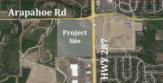
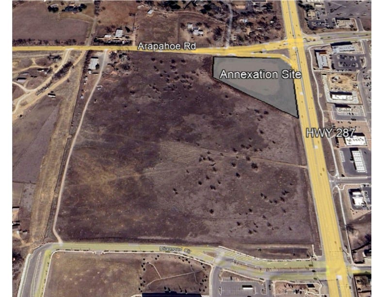
I’ve written extensively about this 40-acre property and the proposed development. Steven Tebo, a familiar name in Boulder County, owns it. As you can see, it’s at the southwest corner of Arapahoe and 287, across from Erie’s Nine Mile Corner. The Silo development is directly to the west, Kohl’s and Tractor Supply are to the south.
Notice the small piece at the southwest corner is not colored green. That’s what’s shown on the map at the top as “annexation site”, and it’s where we are headed in the Karensplainer.
In May 2023, I started writing about the plans for this property by the Illinois developer Kensington. The first neighborhood meeting about it was held on November 7th, 2022. I was there. Originally called Lafayette Marketplace, it’s now The Range at Lafayette. The latest plans can be seen here.
This property is currently in Boulder County. Boulder County regulations only allow for one dwelling unit on 35 acres. To develop, it must become part of a municipality. That requires annexation.
DOT NUMBER THREE - THAT ODD LITTLE CORNER PIECE
Here’s a twist in the story: that piece is in Erie. It was a detention pond. Long abandoned, it became a hot spot for local wildlife and is beloved by many who drive by. For those new to the area, Nine Mile Corner was once a reservoir full of water, and this detention pond across 287 was part of a watery ecosystem.
From the outset of this proposed development, many residents (I wave my hand) have raised concerns about what will happen to this wildlife habitat and advocated for its preservation and the protection of its inhabitants. Though commonly called a wetland, it does not meet the official definition.
DOT NUMBER FOUR - ERIE NEEDS WATER STORAGE FOR NINE MILE
There are issues regarding water supply to the Nine Mile Corner development for fire protection. Erie would like to have a tank to store water close by. It needs to be at a higher point as gravity is involved, and as you know, water flows downhill. The Tebo property is higher than the Nine Mile Corner property. It’s my understanding that talks between Erie and Tebo regarding water storage on his property have been going on for years.
DOT NUMBER FIVE - THE ERIE/LAFAYETTE GLOBAL AGREEMENT
I have also written extensively about this topic. There’s a lot of history about the rocky relationship between the two communities in this piece, Deep diving at 287 and Arapahoe! leading to condemnation, lawsuits, and a lot of animosity.
In June 2019, the two communities created an Intergovernmental Agreement (IGA), also called the global agreement or settlement, finding a path forward away from conflict and toward cooperation. I wrote about it here: Lafayette and Erie come to an agreement, gasp! It covered a variety of issues, including both communities sharing revenue collected at Nine Mile Corner and at the Tebo property. I wrote about that here: Sharing the money pot.
The IGA addressed the Boulder County Tebo property by specifying that if annexed, it would be to Lafayette. However, don’t forget that corner piece; it’s in Erie, not Boulder County.
DOT NUMBER SIX - ERIE, THE IGA, AND THE WATER TANK
One point in the IGA speaks to the need for Erie to have water storage for Nine Mile. The IGA created an easement as a buffer between Nine Mile and Lafayette’s Beacon Hill, and building an underground or above-ground tank in the easement was an option. The IGA says ”However, if Lafayette is willing and able to accommodate the fire flows necessary for the Nine Mile Property without the necessity of the on-site water tank and at a lower cost to Erie and the developer of the Nine Mile Property, then the on-site water tank shall not be permitted in the Easement Area.”
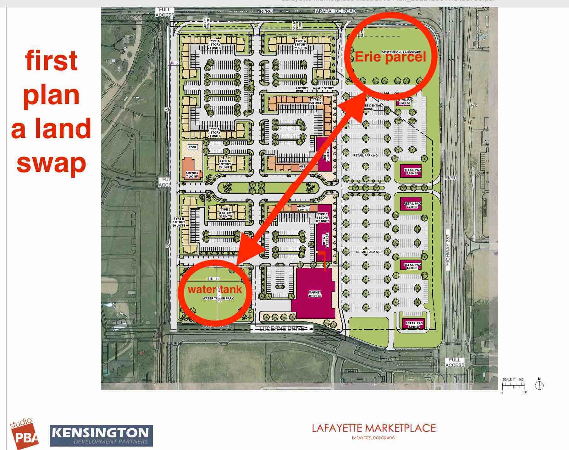
DOT NUMBER SEVEN - LAND SWAP?
As the Kensington development plans came forward, they showed a potential land swap related to the water tank. Look at the southwest corner of the property itself, which would have the water tank, and there would be a swap for the Erie parcel at the corner. If it went forward, Erie would deannex its land back to Boulder County, and that would free it up to become part of Kensington’s development. Erie would then have its water tank on a high spot on Tebo.
A later plan did not include the water tank. I was told by the developer’s representative that Erie didn’t need one any longer. That turned out not to be the case.
DOT NUMBER EIGHT - LAFAYETTE’S PLANS FOR A SECOND WATER TREATMENT PLANT
In 2017, the city of Lafayette purchased this 2.89-acre property with the intent to build a second water treatment plant. It was zoned T-1, which is a transitional business district. The general purpose of this zone is to be a transition from residential to commercial. It runs along Aspen Ridge Drive, and the cross street is Timber Trail.
A later study revealed the property was not large enough for the proposed plant.

DOT NUMBER NINE - A PLACE FOR ERIE’S WATER STORAGE
Erie’s staff thought this property would be the right spot for their water storage. An agreement was reached, and in May the city council approved a purchase and sale agreement with the Town of Erie for a million dollars, which will be deposited in the city’s water fund. The sale was contingent on Erie deannexing and selling its “odd little corner piece” to Tebo, which would allow it to be annexed into Lafayette.
The zoning has been changed from T-1 to P, which means public.
This property will still be part of Lafayette, but owned by Erie. The final storage design is not yet complete, but it will go through the standard development review process.
The property will connect to Erie’s water supply, not Lafayette’s.
City staff is saying an early study is showing the tank will be at grade or below, meaning mostly below ground. Staff is also saying it will be a lot less intensive than the planned city water treatment plant, which would operate constantly with employees on site, and be above grade.
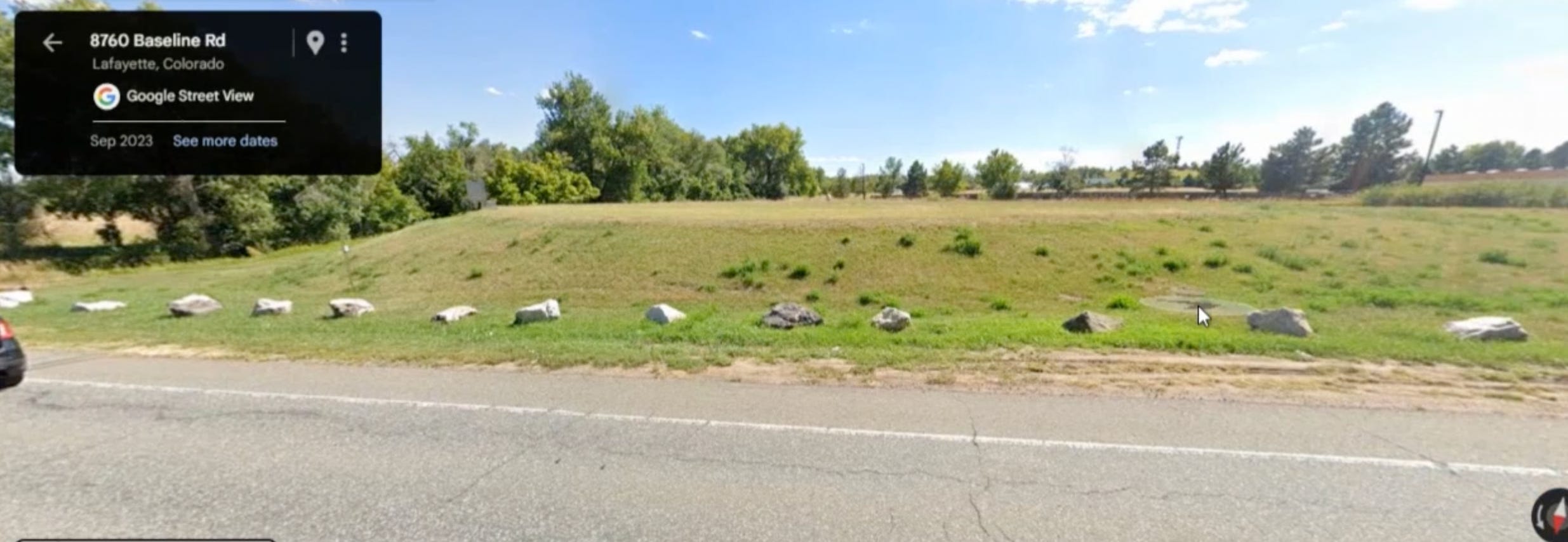
During the planning commission’s rezoning hearing, staff said Lafayette has a similar below-grade tank adjacent to the water treatment plant on Baseline. Using Google’s street view, they showed the commissioners what it looks like. Here’s a screenshot.
ABOUT THE TWO ZONES
Staff presented a comparison between the T-1 zone and the P zone to the planning commissioners.

Staff explained that although there is no setback in the public district compared to the T-1 district, there is a 30-foot easement on the western edge that would provide buffering.
The commissioners raised concerns over the increase in height allowed in the public district and its effect on the residential neighborhood to the west, Silo. After the discussion, the commissioners added a condition to their approval of the zoning change, to the council.
From the meeting minutes
“Commissioner Ortiz moved to approve resolution No. PC-2025-03 recommending approval of the rezoning of certain City-owned real property legally described as Lot 1A, West Ridge Filing No, 1, Replat A, in the City of Lafayette, From the Transitional Business (T1) Zone District to the Public Zone District with the condition that the height limit of the property be restricted to a maximum of 27 feet or any lower height limit that will apply to the property under any new zone district regulations enacted by the City Council in the future, whichever is less.”
The motion passed 6-1 with Commissioner Mettler casting the no vote.
WHAT HAPPENED AT COUNCIL
From the meeting minutes
“A motion was made by Mayor Pro Tem Wong and seconded by Councilor Fridland to approve on first reading Ordinance No. 11, Series 2025, rezoning certain City-owned real property legally described as Lot 1A, West Ridge Filing No. 1, Replat A, in the City of Lafayette, from the Transitional Business (T1) zone district to the Public zone district.
Councilor Samson moved, seconded by Councilor Barnes, to amend the motion to add a condition to limit the maximum height of development on the property to 27 feet. The motion passed 5-2 with Mayor Pro Tem Wong and Councilor Fridland opposed.
The main motion, as amended with the 27-foot height limit, passed 7-0.”
BACK TO WHERE WE STARTED
We’ve jumped from dot to dot and have arrived back at the annexation of that “odd little corner piece”. Erie has its water tank location and can deannex its land back to Boulder County. Tebo/Kensington can incorporate that piece into their development plans and move forward to ask for annexation to Lafayette.
The process to annex the large parcel has already begun. I wrote about it here.
Want to offer more support? Awesome!
Thank you for pulling all of this information together. As a resident of the Silo neighborhood we’re interested in the development of the parcels around us. Have you also looked into the proposed echo suites development? All silo residents are very concerned about this proposed plan.
Thank you Karen for your tireless work to help preserve Lafayette (from scheming developers). Do city leaders (?) take into account the traffic nightmare they will create at that small corner? (Arapahoe & 287) Rush hour traffic barely moves. Let’s see what the city plans for safety & traffic flow at that corner. Or will that be an afterthought?