


Planning Commissioners send Silo developer back to the drawing board: part one
I get very ranty

On April 5th, I wrote about the Silo Phase 2 public hearing at the Planning Commission scheduled for April 9th, if you want to catch up on some of the details. I didn’t watch all of the meeting live, but what I did see was interesting. You can watch the meeting here.
As I began working on this report, I went back to the video of the meeting, time and time again, to get more information to share. The more I looked, the more ticked off I got and the longer this piece became. So here I am on Saturday afternoon, with a crazy number of hours already sunk into this, and I realize if I don’t break it into two pieces, I am never going to get it finished! I’m going to explain the process a bit and then get into the ranty part, which is about something near and dear to my heart, open space.
Let’s hit the process.
WHAT THE AGENDA SAYS
A. Resolution No. PC-2025-01/Recommending Approval of the Silo Phase 2 Planned Unit Development Sketch Plan (10364 Arapahoe Road) [Public Hearing/Noticed in the Daily Camera on March 28, 2025]
HOW THE COMMISSIONERS VOTED
On a 5-2 vote, with Commissioners Watson and Wilson casting the no votes, the commission referred the Sketch Plan back to the developer, calling out four topics for additional study. The disagreement shown by the split vote was not about the topics themselves but the method of handling the commission’s response. I’ll get to more details about that in part two.
FIRST, WHAT WAS THIS MEETING ABOUT?
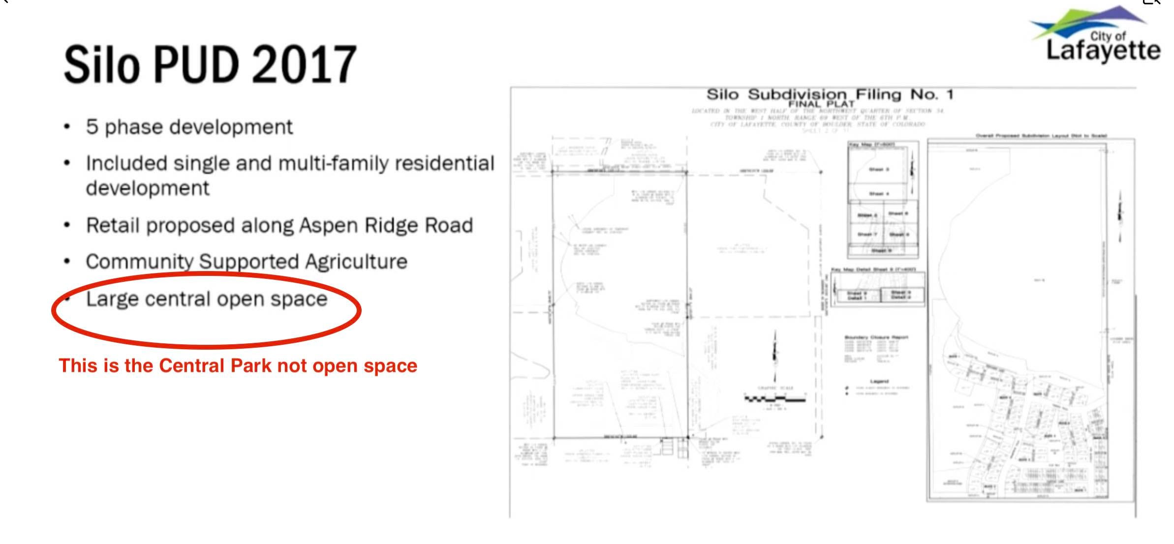
The Silo project has already been approved. The plan was to build in phases. Phases 2-5 have been combined into phase 2. Due to the number and scale of the changes, which include zoning, the city staff asked the developer to submit a new Sketch Plan. Oddly, two developers are working on this project, Cornerstone was the first and was joined by Lennar Colorado on phase 1. Lennar is now the applicant for phase 2.
No one from Lennar was at the meeting, nor was the property owner, which the chair noted a time or two. It’s hard to ask questions when the developer is not represented. However, Al Cunningham the planner working for Lennar, was there to give the presentation. I snagged the image above from his slide deck. It shows what the first plan looked like and what is now being proposed.
WHAT THE HECK IS THIS PUD AND SKETCH PLAN THING?
Since there is a lot of development on the horizon this might be helpful to understand. The staff memo for this project gives us an explanation of this process for Planned Unit Developments or PUDs, which includes the Sketch Plan.
“Review Process
The Sketch Plan application is the first step in the City’s Planned Unit Development (PUD) process and is required for all mixed-use building complexes and residential development over 20 units or 5 acres in size. The PUD process includes Sketch, Preliminary, and Final Plans.
PUDs are intended to promote the most beneficial and creative development of land within the City, permit greater flexibility in the location of buildings, mixtures of land use, and open areas to promote more imaginative design for development than would be generally possible under conventional zoning or subdivision regulations. PUDs are intended to promote a high level of landscaping and common area amenities, convenient and safe vehicular circulation, and creative residential, commercial, and industrial development consistent with the Lafayette Comprehensive Plan and other approved city plans.
As the first step in the PUD process, the purpose of Sketch Plan review is to evaluate the appropriateness of the proposed development, identify major problems that must be resolved prior to proceeding to the Preliminary Plan, and to assess the overall feasibility of the request (Section 26-16-4). The Sketch Plan does not include any technical review for feasibility, such as utility and traffic studies. Those analyses will be provided should the project advance to the Preliminary PUD Plan stage.
Per Section 26-16-4(c), approval of the sketch plan does not bind the planning commission or city council to approve subsequent plans, nor does it confer on the applicant any vested rights.”
PLANNING COMMISSION’S ROLE
From the staff memo:
“Using the criteria specified in Section 26-18-5 of the Lafayette Development and Zoning Code (DZC), Planning Commission is tasked with reviewing the application in conjunction with staff’s recommendations and input received from the applicant and public, and approving the application as submitted, approving the application with conditions, denying the application, or referring the matter back to the applicant for further study. The Planning Commission’s decision will be forwarded to City Council.”
The Planning Commission makes the final decision on the Sketch Plan, not the City Council.
QUASI-JUDICIAL
Just a reminder about this. During a quasi-judical hearing the Planning Commission and the Council act as a judge would and can only consider evidence presented to them during the public hearing. If you stop them in the grocery store or the gym and say hey I hate this, or I love this, they cannot consider that at the hearing. That’s why it is so important that they get the correct information and if you want them to know something specific, going to a public hearing and speaking is the best way to present your evidence.
CITY COUNCIL
Here’s where I think there is a big glitch in the process. Council doesn’t automatically get to weigh in on these developments early in the process. This has been an ongoing issue in my humble opinion. By the time a project gets to the council it is pretty much a done deal. Lots of time and money has been invested at this point and they have little pull to make changes. To those who lament about why council is letting such and such a development happen, well they really have no say until the end. This needs to change.
I will never forget when the folks from Anna’s Farm appealed a Planning Commission’s decision on 40 North. (Yes, appeals are possible for the applicant and the residents.) This appeal went to the council, and they were engaged and willing to ask for changes to the early version of the plan based on points made by the neighbors during an excellent presentation. They set the bar high; it was outstanding.
COUNCIL CALL-UP
Council can do what’s called a “call-up” and ask to see a project at an earlier stage.
From the staff memo:
“The Planning Commission’s decision will be forwarded to City Council. In this case, the applicant has also requested that their Sketch Plan be considered by City Council. Consequently, staff will present their call-up request to City Council following the Planning Commission hearing.”
This has a few obvious benefits. Not only does council, our elected representatives, get to weigh in early, but it also gives the members of the public an extra opportunity to make their case when changes are easier to make. Just to be clear though, council can make comments on the Sketch Plan if they call it up but the Planning Commission has the final say.
Will the applicant go to council now the planning commission has said do more work? I don’t know.
FAST FORWARD TO THE APRIL 15TH COUNCIL AGENDA
There are two executive sessions scheduled. One pertains to Sketch Plans, and the other seems to be a continuation of the discussion regarding HB 24-1313 the transit-oriented housing bill that many of you have spoken up about.
Pursuant to Section 24-6-402(4)(b) of the Colorado Revised Statutes to confer with the City Attorney for purposes of receiving legal advice on specific legal questions regarding quasi-judicial decisions on Sketch Plans and Sketch Plan review procedures under Section 26-16-4 of the Lafayette Code of Ordinances
Pursuant to Section 24-6-402(4)(b) of the Colorado Revised Statutes to confer with the City Attorney for purposes of receiving legal advice on specific legal questions regarding state preemption and the City’s home-rule authority to regulate zoning and land use
OK, LET’S GET BACK TO THE MEETING
RANTING TIME! THERE IS NO OPEN SPACE IN PHASE 2!!!
I cannot express how disturbed I was to hear Al, the planner for Lennar, continue to use the term open space when he was talking about various areas of green within this phase. I had a lengthy email conversation with our planning and building director after this meeting. Not only did Al use the term incorrectly, but so did the planning staff in their memo and even in slides used during the meeting. Then the commissioners got dragged in on the gig and everyone was tossing around the term open space as if it applied to anything that wasn’t concrete.
A PARK IS NOT OPEN SPACE!!!!! LITTLE DRIPS AND DRABS OF GREEN ARE NOT OPEN SPACE. Sigh. Quick get me some chocolate. With nuts.
WHAT IS OPEN SPACE?
Open space in Lafayette means land the city purchased for our open space portfolio, either alone or with a partner like Boulder County or Louisville. Or land that has been acquired for our open space portfolio via a code requirement to dedicate a percentage of new developments as a Public Land Dedication or PLD.
If nothing is suitable within a development, then it’s cash in lieu at market value, which goes into our open space fund. For residential, it was 12% for years. Grant Swift and I were successful in convincing the city council to increase it to 15% in early 2017. No, the developer doesn’t get to decide what to dedicate, (you can imagine what castoffs we would get! I saw it with Medtronic.) Our open space staff and the Lafayette Open Space Advisory Board (LOSAB), use the wish list, criteria for open space and other factors to say what would be appropriate.
This PLD can also be used for parks, that’s how the city acquired the park land in Silver Creek and South Pointe for instance. Note I said land, the city has to pay for the development of the parks, and the ongoing maintenance which can be very costly. That’s why it is often better to have the developer build and maintain their own parks, which is the case for Silo.
SILO’S PLD - IT’S 9.97 ACRES AND 12.36% OF THE ENTIRE SILO DEVELOPMENT!
Here’s a section of a chart from the original Silo plans that shows the PLD as 9.97 acres which is 12.36% of the entire property for this phased project. THIS IS A SILO CHART!

In 2017 Silo began, and the increase in the PLD to 15% happened in February of that year. I don’t see any mention of the trails in the development being included in this 12.36%, but the next graphic from the plans shows they were part of it. Whatever happened here, Silo is telling us they dedicated 12.36% or just under 10 acres, to the city as open space for their PLD, and the graphic below shows us exactly where that is.
I cobbled this goofy image together using a map from Silo’s plans showing the PLD for the entire development. Yes, it’s sideways in the documents, which is a bit disorienting, sorry.
There’s a section at the northwest corner bordering Arapahoe, which is true open space, and some trails through the development. That’s it. I remember being at LOSAB while this was being discussed. Some of the trails have equestrian access.
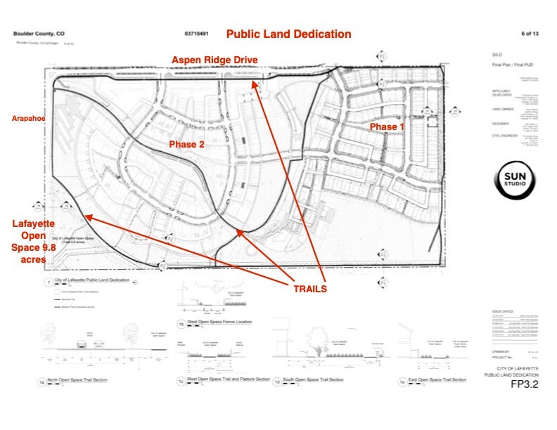
Planning and Building Director Williams verified this, telling me the PLD happened with the initial application, was just under 10 acres, and is just west of Phase 2. You can see that in the sideways map above. He also verified that the development has private internal green spaces, parks, ag land, and detention areas. He said there are no proposed changes to the public land area (there better not be, that’s not permitted. If the city wants to sell open space, we have to vote on it), and areas referred to as “open space” at the meeting were ag and park lands. He also told me that going forward he will ensure this distinction is known to all parties. Yeah! I hope I never have to do this type of analysis again.
THE DEVELOPER’S PLANNER’S GRAPHIC
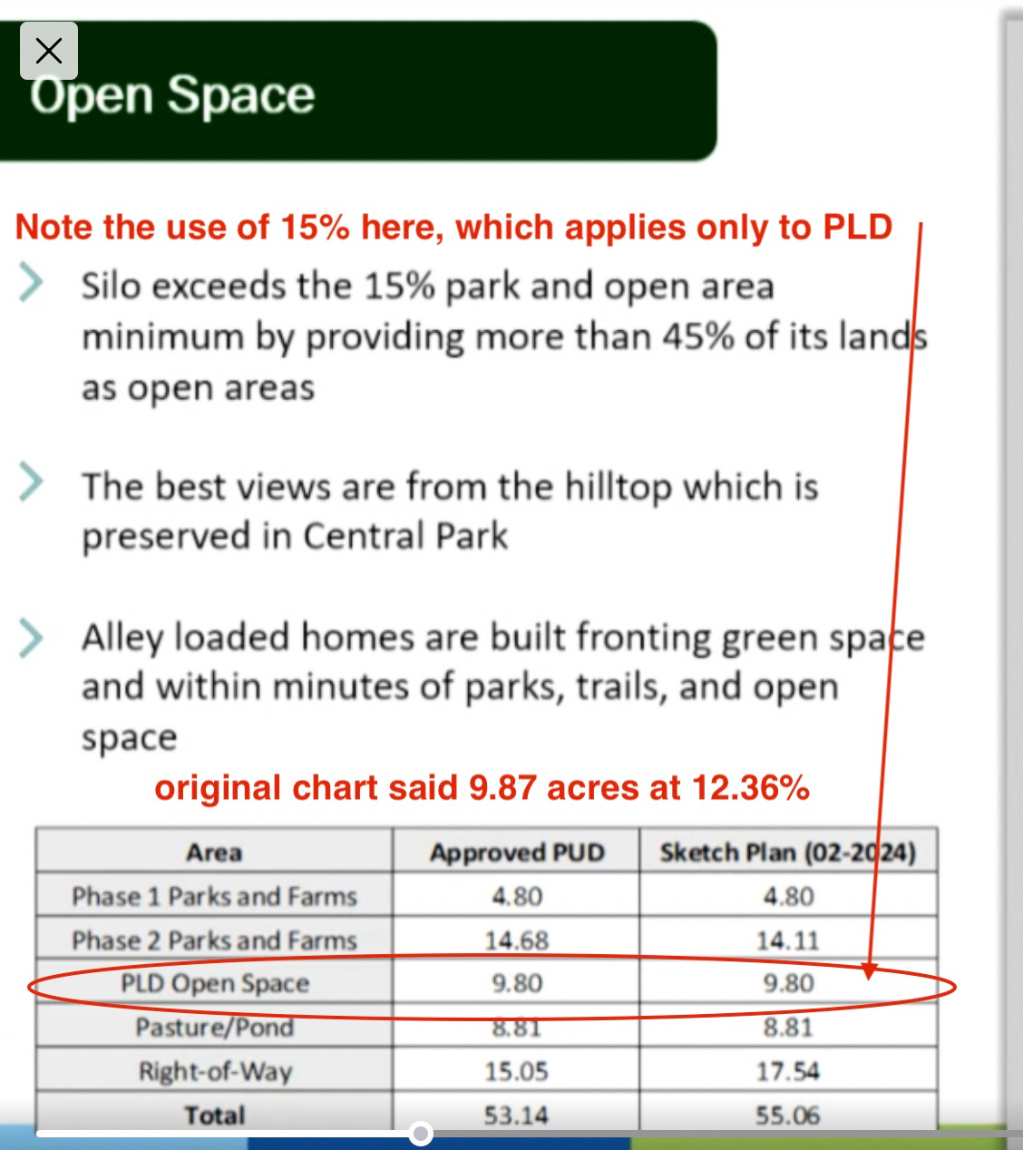
Back to Al. He had this graphic, to which I have added a couple of comments. All that other stuff listed in his chart is not open space, yet that’s what he calls this slide. The more I look at this, the more I have to laugh and groan. (I reach for a nutty chocolate bar, or two)
The only thing that applies to open space is that 9.80 acre PLD which we know from their own document is 12.36%, not 15%. What do the best views from Central Park and alley-loaded homes have to do with open space? Nothing.
As Al is talking to the commission about these slides he continues to call the green areas open space. He also continues to say how much more they have than “that 15%”.
Dude, you barely have 12%, stop flaunting this 15% number. (is that you chocolate, my love?)
Why is right-of-way included in this chart?
Here’s Al’s graphic showing what is official open space, even if the colors are off. (insert eye roll here) The pasture is the brown area at the bottom left. Should there be trails shown through the development according to the graphic we saw above?
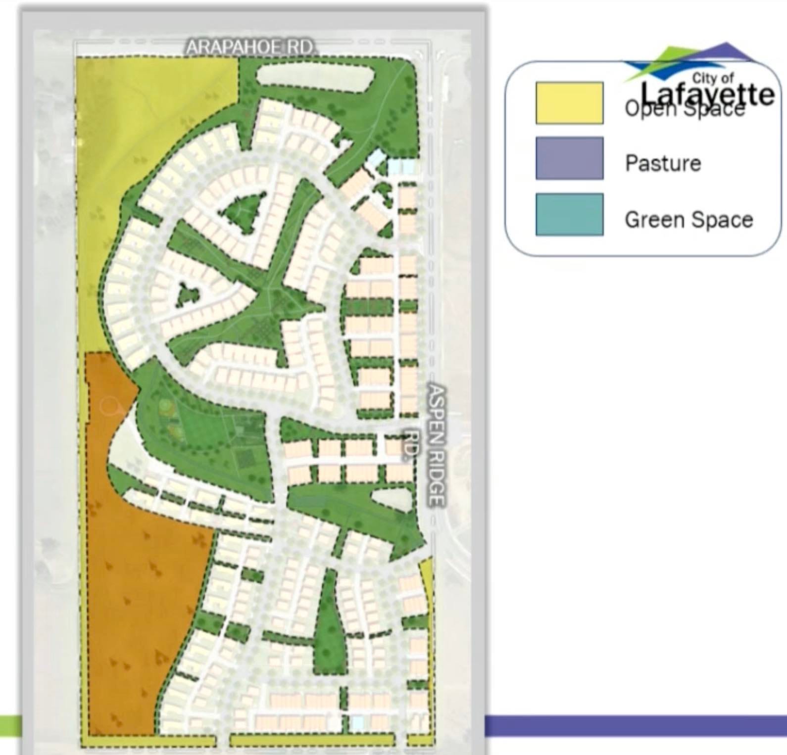
At one point Al says there are 37.5 acres of open space, and says there is a reconfiguration of open space in the new plan. NO THERE ISN’T! Open space can’t be reconfigured.
THE PASTURE
It came out during the meeting that the pasture is still owned by Sue Weems, the owner of the land that is now Silo. Al said it’s private property. You can see from the graphic though, a city trail runs along the western edge. Maybe one day, this too will be developed. It is included in the calculations of that 45%, combined with the detention pond.
STAFF OPEN SPACE COMMENTS
The current planning staff is fairly new, some were hired this year, so there isn’t a lot of institutional knowledge left in the planning department. None of the staff were working for Lafayette in 2017 when this project began. However, Commission Chair Darcia Thomas was on the planning commission at that time.
Here’s a slide City Planner Rounds showed the commission, right out of the gate, with my comment in red.
Here’s a point from a slide showing the staff’s analysis of the overall plan. It says open space is provided throughout the development.

Here’s a slide from staff’s presentation showing the zoning. See that blue section? That’s called public on this slide because we own it as open space. It’s the PLD as we see in the other graphics. That’s the only piece of open space in this development. It is not provided throughout the development. Do these trails provide connections to the rest of the city? I can’t answer that. Can you get to Old Town or South Pointe via trail from this location? I don’t know.

THE CSA DISAPPEARS
The original plan had a piece of land planned for a small farm and was promoted as a place for a CSA or Community Supported Agriculture. It was one of the many selling points for this project and touted as being unique. It’s another feature that is no longer there.
When asked about it Al’s partner explained it this way. A CSA is almost like commercial farmers, it’s much more of a business entity than just a farm option. At the time it was included but adding the operation of the farm within a metro district (that’s what Silo is) would require every resident to contribute to it. So they replaced it with community gardens for everyone to use and they can still have their own central farmers market. It was a bit of a confusing explanation folks. But we can draw the conclusion that it was a pie in the sky idea that sounded good on paper but wasn’t workable, even though it was one of the reasons people bought a home in phase 1.
ONE MORE THING BEFORE MY HEAD EXPLODES
You might recall in my last report about this project, I found numerous issues with the section of the Planning Commissioner’s agenda that covered public input. I pointed that out to staff and corrections were made.
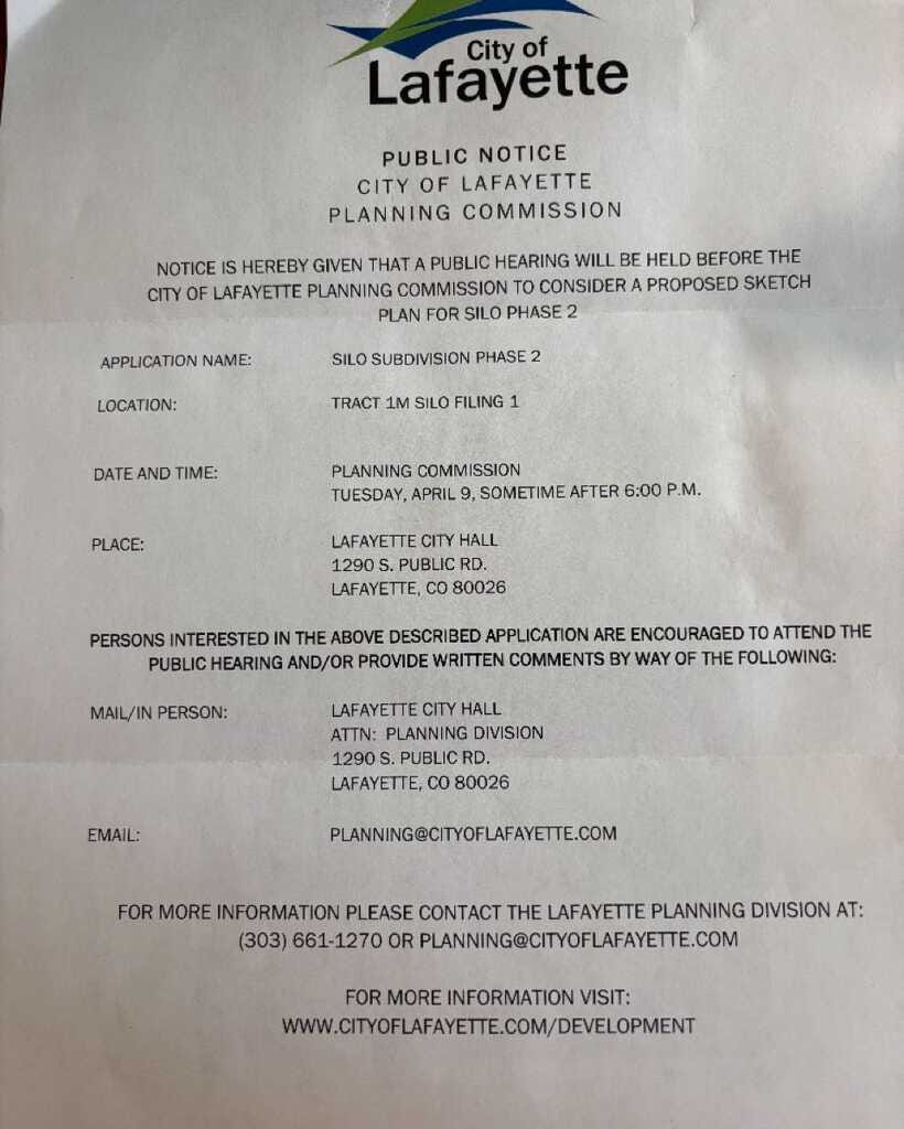
On April 9th I saw this notification that is required by city code to be sent to addresses within 750 feet of a new development.
The day is wrong. April 9th was a Wednesday, not a Tuesday.
It uses the old URL and email address for the city, cityoflafayette.com rather than lafayetteco.gov That change was made years ago.
The URL cityoflafayette.com/development goes to a 404 error page
Again I pointed this out to staff. At the beginning of the meeting City Attorney Macsalka addressed this by saying if anyone had shown up for the meeting on Tuesday they would have seen there wasn’t one and could come back for the meeting the next night. She said the date was correct, and in all other places this information was available, the day was also correct.
I’ll be back with part two as soon as I recover from my chocolate binge.
Want to offer more support? Awesome!
This just shows what would slip by us and turn into corrupt bullshit if we don’t keep our eye on what they are doing in this community. I don’t know how we could ever do that without your dedication and expertise Karen. I hate to think of what our city would be without you. Please don’t ever give up!
I stayed the entire meeting. Fairly well attended by residents and a good number of public comments. I was glad to hear the Planning Commission discussion and elated to see them send it back to the developer for further review. I'm not sure what to except to come back from the developer but they heard loud and clear that it must be better to conform to the new Comprehensive Plan objectives. Fingers crossed 🤞