A Road of Remembrance part three
Recommended location and response from CDOT


The recommendation letter from the Working Group to the Colorado Department of Transportation (CDOT).
February 14, 2023
Colorado Department of Transportation 10601 10th St.
Greeley, CO 80308
Attn: James Eussen
Region 4 Planning and Environmental Unit Manager
State Historic Preservation Office 1200 Broadway
Denver, CO 80203
Attn: Mitchell Schaefer
Section 106 Compliance Manager
Re: Mitigation Working Group Report and Recommendation for After-the-Fact Mitigation Plan for Preservation of the Road of Remembrance Gateway Memorial
Dear Messrs. Eussen and Schaefer:
Pursuant to Mr. Eussen’s letter dated November 18, 2021, a Mitigation Working Group composed of various local civic, veterans, and historic preservation groups has been developing a mitigation plan for the preservation, monitoring, and perpetual maintenance of the Road of Remembrance Gateway Monument (“the Monument”) at the intersection of State Highway 7 and US Highway 287 in Boulder County (“the Intersection”). Over the course of the past fifteen months, the Working Group has examined roughly two dozen alternatives and locations in the Boulder County area. Four public meetings have been held to gauge public sentiment. The Working Group also consulted a variety of local governmental agencies, engineers, masonry specialists, landscape architects, and other professionals concerning these options.
Based on this work, the Working Group met on February 8, 2023, and reached the following consensus recommendation concerning a mitigation plan.
SUMMARY
The Working Group recommends that in order to mitigate the impacts identified in the CDOT Cultural Resource Survey 5BL.432 dated October 7, 2021 (“the Survey”), the two stone pillars comprising the Monument should be relocated to a small area to be redeveloped approximately 150’ north-northeast of their current location, on the NW corner of the Intersection.
As discussed in more detail below, the stone pillars would be re-erected side-by-side facing southeast toward the intersection, and the new site would be developed and landscaped to incorporate a number of the historic design elements from the original Gateway site. While substantial additional thought must be given to the final design, below is a concept drawing of one possible iteration of this site:

Because the planning and execution of the relocation project likely will take several months or possibly years, the Working Group also recommends that prompt, interim steps be taken to partially mitigate the impacts on the Monument pending completion of the relocation.
BACKGROUND
Much of the background to the current situation with the Monument is outlined in detail in the Survey and its attachments, and will not be repeated. In brief, the current situation arose when a developer, Evergreen-287 & Arapahoe, LLC (“Evergreen Devco”), operating under the aegis of the Town of Erie Urban Renewal Authority (TEURA), obtained a permit from CDOT to reconfigure the Intersection. This reconfiguration was part of a large real estate project called Nine Mile Corner that Evergreen Devco developed on land owned by TEURA on the southeast corner of the Intersection.
When the development was initially proposed in the mid-2010s, the publicly available planning documents did not suggest that the project would involve any significant realignment or reconfiguration of the traffic lanes on Arapahoe Road west of the Intersection in the vicinity of the Monument. Those documents instead reflected that the then-existing traffic lanes on Arapahoe Road – which passed between the two stone pillars of the Monument – would be unaffected.
In late summer 2019, Evergreen Devco proposed a dramatic change to this plan to TEURA and the Town of Erie. Under this new plan, a right turn lane would be constructed south of the south pillar of the Monument to provide space for an additional traffic lane between the pillars. In addition, a large “pork chop” traffic island would be constructed surrounding the south pillar to both create traffic separation and facilitate drainage on that portion of the roadway. To accommodate this island, engineers proposed raising the grade at the south pillar by roughly 2 feet.
As CDOT later found in its Survey, this new design (a) substantially diminished the physical integrity of the Monument, (b) greatly impacted the integrity of the Monument’s historic setting, and (c) added a new and serious vehicular hazard. Moreover, as subsequently became apparent, by raising the grade on the “pork chop” island, the bottom portion of the south pillar – including the cornerstone and door – were buried in 2’ of dirt.
This new design was approved by TEURA and the Town of Erie, and the revised plans were submitted to CDOT and Boulder County. Both agencies apparently were made aware of the plan to construct the new right turn lane and isolate the south pillar on a “pork chop” island. However, neither agency was specifically advised that the construction of the “pork chop” island would result in burying the south pillar in 2’ of dirt. That fact may have been discernible by careful study of the engineering documents but, to our understanding, the fact that the lower portion of the pillar would be permanently buried was never specifically brought to the attention of any of the appropriate governmental agencies.
After being advised of the revised plan, Boulder County requested that Evergreen Devco prepare and provide the County with Level II documentation, a structural assessment, and an impact study of the project on the pillars. Though it does not appear that CDOT made any new requests, its regulations stated that the permittees (TEURA and Evergreen Devco) should not proceed with work that could impact historical resources such as the Monument without fully advising and obtaining authorization from the CDOT Regional Permitting Office and Region Planning and Environmental Manager.
Based on our investigation, it does not appear that the Level II documentation, the structural assessment, or the impact study requested by Boulder County were prepared by Evergreen Devco. Similarly, it does not appear that TEURA or Evergreen Devco complied with the CDOT requirements. It also appears that none of the responsible agencies – CDOT, Boulder County, or the Town of Erie – followed up to ensure that those requirements were met.
Equally important, the substantial change in plans to isolate one pillar of the Monument on a “pork chop” island in the middle of traffic and partially bury it in dirt was never announced to the public or brought to the attention of SHPO or any state, county, or local historic or veterans organization. Instead, the plan proceeded essentially unnoticed and unvetted until the work was nearly finished.
NECESSITY FOR RELOCATION
The Working Group began its work in this context. Some members of the public asked that the work on the Intersection be stopped and the damage “undone” by restoring the roadway to its original alignment. Given the expense and interrelationship of the west side of the intersection to the remaining roadway configuration, this simply was not feasible.
Others strongly objected to any mitigation plan that required the relocation of one or both pillars. Under this view, an overriding tenet of historic preservation is to maintain a physical structure in its original location regardless of changes in the surrounding area. These voices felt that the Monument should remain in its current location at all costs, regardless of the dramatic changes to the visual setting and the increased risks to its integrity.
The Working Group carefully considered this view, and ultimately rejected it. Leaving the pillars in their current location does little to resolve the issues identified in the Survey. Even if repairs were made to the pillars and improvements were made to the “pork chop” island, the impacts on the Monument’s physical integrity and historic setting, as well as the vehicular hazard, would remain. Moreover, the Working Group is aware of no feasible engineering solution – short of completely rebuilding the Intersection – to lower the grade and “unbury” the south pillar.
Further, the current setting greatly diminishes the builders’ original goal of honoring those men and women from our community who served in WWI. That purpose unquestionably faded from the public consciousness over the years, long before the current reconfiguration project. But prior neglect does not justify further ignominy. The Monument was intended to serve a worthy public purpose, which this generation should continue. Leaving the Monument in its current state will not meet that obligation.
Finally, both CDOT and County representatives have made it clear that at least the south pillar must be removed when the planned State Highway 7 Transit Corridor is constructed. While a definitive timetable for constructing that Corridor is unclear, it likely will occur within the next 15-20 years. Leaving the Monument in its current location accordingly would be only an interim solution, subject to all of the defects and inadequacies discussed above, at most for two more decades.
For these multiple reasons, the Working Group determined that the Monument must be relocated, repaired, and restored.
RECOMMENDED RELOCATION PLAN
As previously mentioned, after months of investigation and discussion, the Working Group recommends that the Monument be relocated to the NW corner of the Intersection, approximately 150’ north-northeast of its current location. This location was selected for several reasons:
The Monument would remain in the East County, near its historic location and visible to thousands of residents each day.
The new location of the Monument should not interfere with any reasonably foreseeable, future intersection widening projects.
The area would make an attractive setting and provide space for honoring those who served in WWI.
The location would have public access, and facilitate foot and bicycle traffic across the Intersection.
While many details of this relocation plan remain unanswered or open for further discussion, the Working Group spent considerable time investigating its feasibility. Based on this research, the Working Group recommends that the following steps be taken:
1. A publicly controlled property should be assembled on the NW corner of the Intersection as the new location the Monument. One lesson learned from the history of the Monument is that it must be located on land controlled by some public body which is committed to maintaining and protecting it in the future. The area recommended for the relocation of the Monument includes both portions of the existing CDOT right-of-way along State Highway 7 and US 287, and an adjacent, privately-owned 0.6-acre parcel. Accordingly, the first step should be to acquire the 0.6-acre parcel and place it under public control.
Over the course of the past several months, the Working Group has opened discussions with the current owner of the parcel, who indicated a willingness to consider disposing of that tract. One proposal under discussion is for the parcel to be acquired through donation in a manner that provides tax benefits for the owner. While the details of such an acquisition are beyond the scope of the Working Group’s expertise, it may be possible for these tax benefits to accrue from a donation directly to CDOT. Alternatively, it might be more advantageous for owner to contribute the land to a 501(c)(3) entity, which in turn could transfer the parcel to CDOT. Such arrangements would need to be negotiated with the owner but if the latter option is chosen, members of the Working Group stand ready to assist in facilitating the transfer.
After the 0.6-acre parcel is transferred to CDOT, a defined area composed of both that parcel and portions of the existing CDOT right of way should be set aside for the Monument and associated features (hereafter “the New Gateway”). The precise boundaries of the New Gateway will need to be defined with the assistance of professionals, but presumably would include the entirety of the 0.6-acres parcel, plus so much of the existing CDOT right of way as required for the relocation of the Monument and construction of any associated features.
2. A design for the New Gateway should be prepared with professional assistance and public input. While the concept drawing displayed above is an impressive first step, substantial additional work will be needed to finalize the design of the New Gateway. As this process unfolds, the Working Group recommends that this final design:
Strive to capture many of the design elements from the original 1928 Road of Remembrance Gateway such as the orientation and spacing of the stone pillars, the wye gateway configuration, and the triangular memorial park, while engaging travelers with interesting and varying views of the structures from the adjacent roadways;
Enhance the memorial purpose of the original Gateway by honoring those who served this country and telling the story behind its construction with interpretive signage and other features;
Adopt the original vison behind the Road of Remembrance by creating natural spaces and using environmentally sound practices on the New Gateway parcel that promote the community’s goals; and
To the extent feasible, provide for access to the New Gateway for the public from adjacent areas.
The Working Group further recommends that the process of community engagement continue. The Monument is part of the County’s heritage and while the New Gateway cannot be designed by the committee of the whole, the design process should be transparent and consider community input. For example, it is likely that the northern portion of the 0.6-acre tract will not be used for the relocated Monument. Input should be solicited from neighbors and others in the community to find an appropriate use for that ground, compatible with the New Gateway’s goals.
3. Relocation of the Monument must meet historic preservation standards, while construction of the New Gateway should reflect current environmental and safety practices. Putting aside the impacts from Evergreen Devco’s construction, the Monument’s stone pillars have been neglected for far too long. The relocation of the pillars will provide an opportunity to repair and refurbish the pillars, preparing them for the next century or more of service. This work should be consistent with relevant historic preservation guidelines, while at the same time insuring the pillars’ stability and durability.
The construction of the related features of the New Gateway such as signage, walkways, and plantings should be compatible with the historic design of the Monument, but also reflect current best practices and standards. In particular, environmental sustainability should be a hallmark of the area.
4. Clear agreements should be put in place concerning the future maintenance and protection of the New Gateway. Another lesson learned from the history of the Road of Remembrance Gateway is that responsibility for the maintenance and protection of the memorial must be clearly settled. Put bluntly, the original Monument was forgotten by the relevant authorities, allowed to deteriorate, and ignored as competing uses for the land intruded. Civic groups, typically the watchdogs raising the alarm about governmental inaction, were silent. Those omissions cannot be repeated.
The Working Group accordingly recommends that the responsibility for the maintenance of the New Gateway be assumed by one or more of the relevant agencies: the State of Colorado, Boulder County, the Town of Erie, or the City of Lafayette. Though the details of such an arrangement are best left to the relevant authorities, the Working Group recommends that through intergovernmental agreement or otherwise, the relevant agencies reach a formal agreement on these issues to avoid a repeat of the current situation in future years.
5. Funding for the design and construction of the New Gateway must be a key priority. As reflected above, the urgent need for mitigating the damage to the Monument – and hence a relocation plan – resulted from the impacts created by the intersection reconfiguration promoted and designed as part of the development at Nine Mile Corner. If County of Boulder requests and CDOT requirements had been voluntarily met or administratively compelled, the current situation with the Monument would be much different. None of that occurred.
The Working Group believes that it is incumbent on those entities who should have avoided impacting the Monument or protected it in 2019 and 2020 to now lead the way in funding the mitigation plan. This perspective is not as a matter of finger pointing or laying blame, but as part of a community effort to save and reinvigorate part of our heritage. The plan outlined above not only saves the Monument, but bolsters and enhances its original purpose. If the relocation plan is implemented, some members of the Working Group will continue to work on those enhancements, including assisting with fundraising for many of the features previously discussed.
INTERIM MITIGATION STEPS
One indicator of the developer’s and regulatory agencies’ indifference to the Monument was the failure to design or implement any meaningful landscaping, beautification, or even minimal protection of the area around the Monument as part of the intersection work, or to arrange for any maintenance of the that area after construction was completed. Instead, the sole planning called for planting “native grasses” on the pork chop island, and moving on.
It is unclear to the Working Group whether even that minimal restoration occurred. In any event, after construction was completed by the developer in the summer of 2022, the pillars were surrounded by tall weeds with no plan for any routine maintenance of the area.

Given the planning and preparation needed to implement the relocation plan, it is apparent that the Monument will remain in its current location for many months. The Mitigation Working Group does not believe that a historic memorial to Boulder County veterans should be left in the current condition during that period. Instead, the Working Group recommends that an interim plan be implemented to mitigate the existing degradation of the area around the Monument, pending the future relocation. At a minimum, the interim plan should include the following elements:
The existing construction debris piled on top of and in the vicinity of the Monument should be immediately removed;
Using environmentally sensitive methods, weed control measures should be undertaken in the areas surrounding both the north and south pillars;
While the original grade around the south pillar cannot be restored due to the design of the intersection reconstruction, professionals should be consulted to minimize any further damage to that structure during the interim period;
Temporary ground cover such as stones or pavers should be installed on the areas in the immediate vicinity (e.g., 10’-15’) of both pillars to eliminate vegetation and somewhat enhance the pillars’ setting; and
Arrangements should be made for periodic weed control, mowing and/or other measures to maintain the remainder of the area until the relocation is completed.
While it is outside the ambit of the Working Group’s mandate to make recommendations concerning the future of the “pork chop” island after the Monument has been relocated, the original “native grasses” plan seems inappropriate for a primary and highly visible entrance to both Erie and Lafayette. Representatives of those municipalities, the County of Boulder, and the owners of adjacent properties may want to consider the future of that area, and design a more attractive space. If that work could occur in the next few months, it could be coordinated with an interim plan and further demonstrate respect for the Monument during the interim period.
CONCLUSION
We hope that CDOT and SHPO concur with these recommendations, and look forward to working with all of the stakeholders to restore the Road of Remembrance Gateway and honor those who served our country in a time of peril.


March 29th 2023
I wanted to give all of you an update on the progress being made at the Road to Remembrance Monuments, especially as related to the interim mitigation measures and measures we
* Trash and debris was removed by Evergreen Devo
* Held an on-site meeting with Greg Fisher and CDOT Region 4 hydraulic engineer to discuss drainage and landscape concerns and potential solutions regarding current conditions at both the south and north pillar. Outcome; Greg Fisher is developing conceptual plans for the sites, including drainage and landscape concepts that will be provided to the working group for their review, feedback and implementations. It's anticipate Greg could have concepts ready for review sometime in April
* CDOT is currently in the process of securing a contract to assist with structural surveys to determine the extent of any possible movement of the south pillar. Efforts should begin in mid April
* CDOT Environmental is currently coordinating with CDOT Engineering to determine and identify any potential roadway projects planned for, in the immediate future as well as within their long-range plans, for the Arapahoe Road/US 287 intersections. Knowing what future transportation needs are planned for this area, including the area selected for the prefered Monument location can help determine if the site can/should be considered as a permanent location for the Monument.
* Work on securing a contract with a firm that can perform recommendations identified by Greg Fisher and agreed upon by the working group.
As we move forward I will continue to provide updates as tasks are completed and contracts are in place.
Please let me know if you have questions.
--
Jim Eussen
Planning and Environmental Manager, Region 4
May 19 2023
All,
I recently received a couple of updates from CDOT that, though still “preliminary,” show significant progress. To summarize:
* CDOT has determined that that the NW Corner relocation site is feasible from CDOT's perspective. Accordingly, CDOT has formally recommended the Working Group’s proposal to relocate both pillars to the NW Corner to the State Historic Preservation Office (SHPO). SHPO’s response is due no later than June 8, 2023.
* If SHPO concurs, formal planning for that relocation will begin. This planning will involve CDOT, the Working Group, and the relevant local governmental entities, and will include:
* Working with the current owner to acquire the parcel for relocating pillars.
* Planning the development of the site.
* Finding the necessary funding to complete the project.
* Arranging for the perpetual maintenance of the site after the relocation is completed.
* No timeline for the final relocation has been developed, but it is hoped that the relocation can be completed within 2-3 years.
* CDOT's regional Survey Unit is monitoring whether the south pillar is actively leaning and will continue monitoring the pillar until relocation is accomplished. If CDOT finds that the south pillar is actively leaning, it will conduct a structural assessment to determine what, if any, risks may be present with regard to the pillar and to the traveling public.
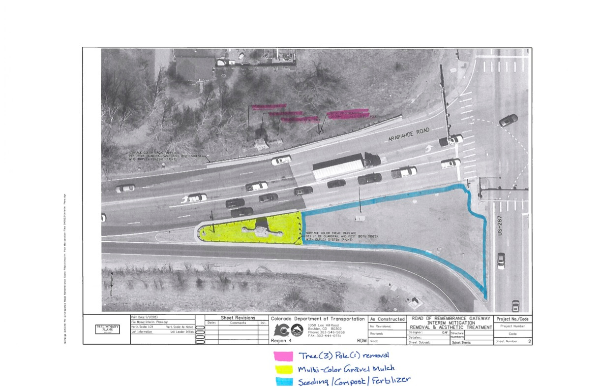
* In the near term, CDOT will complete interim improvements to the south pillar/"pork chop" traffic island as well as any maintenance needed until the pillar is relocated. Attached is a very preliminary conceptual graphic showing a possible interim treatment for the pork chop island and south pillar, which work would be completed in-house by a CDOT maintenance crew. The final plan for this interim work should be completed in the next few weeks.
* On a related issue, my understanding is that a work order has been issued within CDOT for the fabrication and installation of the “Road of Remembrance Gateway” sign east of the north pillar and facing westbound traffic. The best timeline that I have regarding the completion of that portion of the project is that “recent sign orders have taken a handful of months.”
Obviously, these are significant developments and portend real progress. Assuming that SHPO approves the relocation plan, a substantial amount of hard work remains, but we will have reached a major milestone. I’ll keep everyone posted, and perhaps later this summer the Working Group can meet to discuss the various details.
Bill