


A Road of Remembrance part one
What you should know about the stone monuments at Arapahoe and 287.

Undated photo from “A.A. Paddock Collection: East Boulder County,” maintained by the Carnegie Library for Local History, Boulder, Colorado.
This is an edited version of my post on Nextdoor in early 2023. As with some of my other reports I have to bring you up to date on background before I can tell you the latest news.
Over the Christmas vacation I began digging in on available information about these pillars. I knew there were problems and that people were working on them. After I learned more I realized I had to flesh it out in more detail because I haven’t seen any of it shared on Nextdoor, and honestly the more I read the more riled up I got.
I relied on the excellent work done by Bill Meyer of the Boulder Rotary Club, and shamelessly copied and pasted from their website regarding the monuments and various documents shared there. I would encourage you to check out the documents I have linked to as well, there are extensive footnotes. They are full of fascinating local history. If you have questions they are probably answered in these documents.
WHAT ARE THESE MONUMENTS FOR?
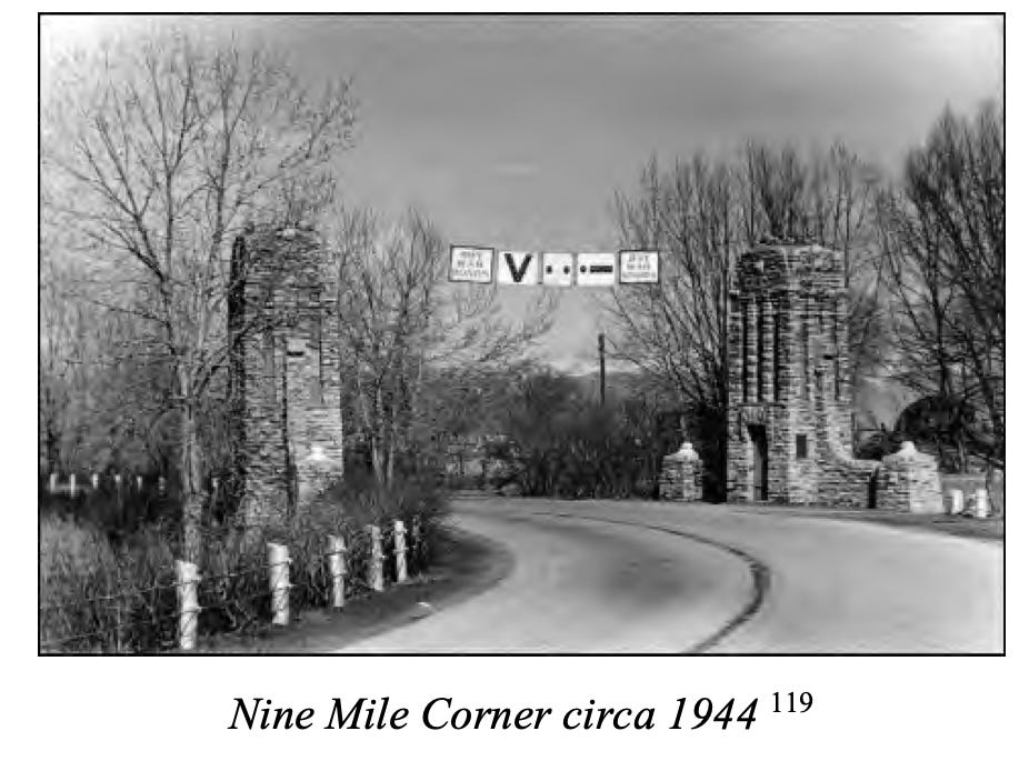
A ROAD OF REMEMBRANCE FOR WORLD WAR 1
“Nearly 100 years ago, a group of Boulder veterans’ and civic groups came together create a Road of Remembrance honoring the men from Boulder County who served in World War I. The proposed Road was planned to follow Arapahoe Road, linking Boulder to a newly built section of the so-called Lincoln Highway (now US 287) in the east County.
Controversy over Boulder’s access to the Lincoln Highway raged for several years, but in 1928 Boulder civic leaders completed a memorial Gateway to the proposed Road composed of two stone pillars and an associated park. Though the Road of Remembrance was never completed, the pillars became a Boulder County landmark at the intersection of Arapahoe and US 287.”

Read more history about them here
Here’s the document you will find at that link
Read much more history here, it’s full of information for local history buffs, with old pictures too. It tells of big concepts, fights between the communities and even a fire.
Here’s the document you will find at that link
Did you know there once was a cannon there?

Undated photo from “A.A. Paddock Collection: East Boulder County,” maintained by the Carnegie Library for Local History, Boulder, Colorado.
Doug Conarroe also has some information about this area on his Lafayette History website: The battle over Ten Mile Corner and how Nine Mile Corner in Erie got its name

Photo from collection maintained by the Carnegie Library for Local History, Boulder, Colorado.
If you prefer watching a video:
ONE PILLAR WAS MOVED IN 1983
“Based on the best available information, it appears that the north pillar was rebuilt – and currently remains – on land acquired for the widening project by the State in 1983 from a private landowner. According to one anecdotal report, the south pillar also was “refurbished” in 1983, though no documents have been located to support that report.”
“After the north pillar was rebuilt, the spacing between the pillars was significantly increased to allow for the additional traffic lanes.
With the completion of the 1983 reconstruction of the intersection, the Gateway as planned and constructed in 1928 had been largely demolished. The two sweeping arcs of the roadway joining at the Monument were replaced by a significantly widened single ribbon of concrete. The park, cannon and flagpole were gone, covered over with hardscape. While it appears that the south pillar remained in its original location, the north pillar had been destroyed and rebuilt 40’ from its original location.”

Louisville Times, Vol. 69, No. 44 (April 20, 1983)
FAST FORWARD TO 2021
HOW THE COLORADO DEPARTMENT OF TRANSPORTATION (CDOT) DROPPED THE BALL AND ALONG WITH THE DEVELOPERS OF ERIE’S NINE MILE CORNER CAUSED MAJOR PROBLEMS
“CDOT issued a permit allowing a private developer to substantially reconfigure the Arapahoe Road – US 287 intersection. Unfortunately, no historic preservation review was performed as required by Colorado law to determine the impact of the proposed construction on the pillars.
The resulting construction has substantially worsened, and in fact endangered, this historic Boulder County landmark. A November 2021 study by the Colorado Department of Transportation (CDOT) concluded that this new construction severely impacted the physical integrity and historic significance of the pillars, and added a new and serious vehicular hazard for eastbound traffic.”
THE BOULDER ROTARY CLUB STEPS IN
“After this situation was raised with CDOT by the Boulder Rotary Club in the latter part of 2021, CDOT conducted a belated, “after-the fact” consultation with the State Historic Preservation Officer (SHPO). Those agencies determined that in order to mitigate the adverse effects of this recent construction, a Mitigation Working Group should be formed to develop a plan for the preservation, monitoring and perpetual maintenance of the pillars.”
THE MITIGATION WORKING GROUP
“Boulder Rotary Club, in cooperation with CDOT, formed such a working group composed of more than a dozen Boulder County civic, veterans, and governmental organizations to analyze all possible alternatives for mitigating the adverse impacts on and preserving the pillars.”
WHAT WAS DISCOVERED AND SUGGESTIONS FOR MOVING FORWARD
“At the same time, the Working Group has analyzed the potential alternatives for mitigating the adverse impacts on and preserving the pillars. As part of that work, restoration specialists inspected the pillars and began developing technical alternatives for their restoration and preservation.”
“The professional specialists have indicated that if the pillars are to remain in their current location, work must be done to repair and restore the masonry and other portions of the structures. If the pillars are relocated, given its age and relative fragility, the south pillar must be disassembled and the salvageable stones categorized. After those stones are transported to the new location, the salvaged stones along with needed replacement stones would be reassembled in the original design.
Though further investigation is needed, it may be possible to move the north pillar, which was rebuilt in 1983, by dividing the tower portion of the monument into three sections, moving each section to the new location, and reassembling the pillar. If it is determined after further investigation that this technique is not feasible, then the north pillar must be disassembled and moved in the same fashion as the south pillar.
Until a final decision has been made, an exact cost estimate has not yet been developed. However, it is anticipated that the total cost of any relocation will be several hundred thousand dollars.”
Documentation of the current situation
Here’s the document from that link
WHAT HAPPENED NEXT?
“ In late July 2022, the Working Group met to discuss the results of these investigations. Some members expressed support for leaving the pillars in their current locations, notwithstanding the recent reconfiguration of the intersection, Others felt that this option was not feasible, and that the pillars should be relocated. The decision was made to begin in-depth studies and planning for three alternatives:”
End of part one