


Why we must preserve the land at Baseline and 120th
Understanding the valuable ecosystem we have saved so far
When you’re heading west on Highway 7 to Lafayette you drive past all those houses in Broomfield’s Anthem, then Flagg Drive, and suddenly it’s all farmland on the south side. The grain elevator and silos are visible in the distance, the red and white homestead is on the left, and you are almost home. It feels great.
With all the development in town, this area is still a rural gateway to our city. That’s because Lafayette, with its sometime partner Boulder County, has purchased most of that land as open space.
THE MISSING PIECE OF THE PUZZLE
There’s one section left to fill in the rural picture and a Texas developer has his eyes on it. The plans will change not only the look and feel of the area but also impact an important piece of the valuable ecosystem the Lafayette Open Space Advisory Board and city staff have been working to preserve for decades. Me too.
WHY I KNOW ABOUT THIS
If you’re new to town, or to reading this newsletter, let me give you some background. Way back in the 1990s, my late husband Toby came rushing into the house yelling “They’re killing prairie dogs at city hall” He started making a protest sign while I looked in the local paper to find out who was running our city. This incident catapulted us into what I call city-watching. As you can see I am still doing it decades later. In the 2000s Toby and I published a weekly e-newsletter about Lafayette for over six years.
I’ve worked on open space and managed growth campaigns (pro of course), was instrumental in getting an ethics code for the city council, and changing the makeup of the planning commission by lobbying for the mayor and two councilors to be removed as members. Voters weighed in and said yes. More checks and balances, please! I took my idea of a community farm for the Thomas Open Space to the city administrator and wouldn’t go away until he told me to go and find a farmer. I served on advisory committees for the 2003 and 2021 comprehensive plan updates and advocated for and against issues across the community.
But after that first foray with the prairie dogs, I started working on something that spanned decades and is near and dear to my heart, saving that eastern rural gateway. I learned a lot along the way.
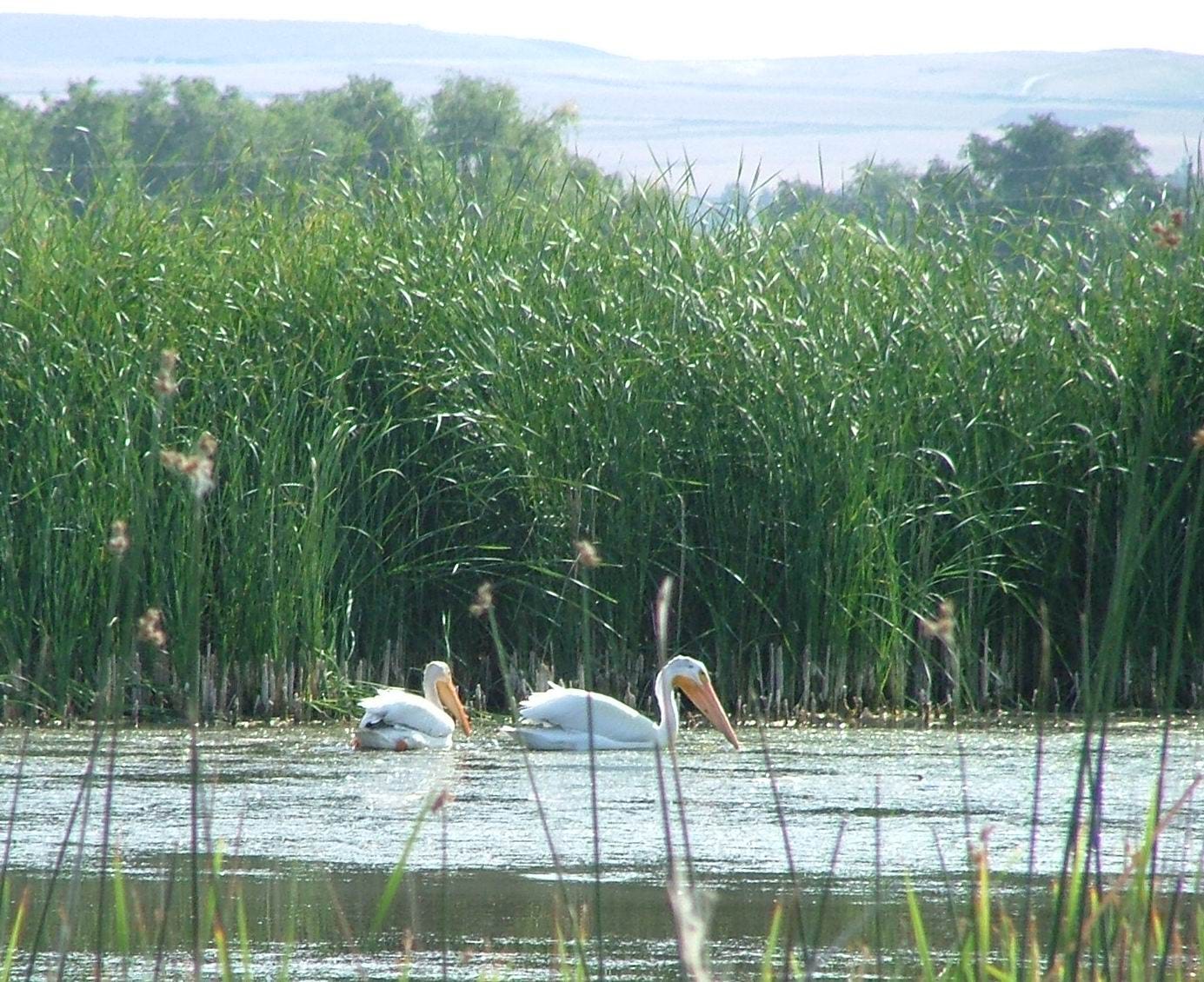
It started with the Old Town Pond just a tad east of Burlington at the edge of town but in Boulder County. It was an amazing jewel that hosted flocks of pelicans at certain times of the year and a variety of water-loving birds year-round. It was a place that rivaled Greenlee Wildlife Reserve in habitat with a fabulous agricultural backdrop. Advocating for the preservation of this pond resulted in my first visit to an open space committee meeting, to speak before the council (Scary, I almost passed out on my way to the podium!) and talk to the city administrator. I knew we should save this special place.
The Pelicans back in the day.
RAILS TO TRAILS
In 2013 the railroad tracks running along the end of Old Town, right past the pond, had become part of the Rails to Trails program. The tracks that carried Lafayette coal and grain out of town were removed and a trail was installed. Former councilor and mayor Frank Phillips told me this was the first project he worked on when he was elected and he voted to approve it at the last meeting in his second term.
THE SILOS AND GRAIN ELEVATOR
In 2013 these iconic symbols of eastern Lafayette, a slow minute walk from the pond, were obtained by the City of Lafayette adding another historic landmark to our open space portfolio.
THE OLD TOWN POND
In 2019 the City of Lafayette purchased the Old Town Pond and a 100-foot buffer running the length of the trail along with a 50-foot buffer down Emma to 120th St.
The Old Town Pond, now called Chuck’s Pond was one of 10 open space properties identified for study in the 2024 Wildlife Plan. It includes a list of strategies for habitat restoration and conservation, including the addition of water, it is currently dry.

Photo taken in May 2023 by yours truly from the Burlington Northern trail at the eastern end of Old Town looking across the city-owned Old Town Pond—now called Chuck’s Pond—to the city-owned Waneka Centennial Farm on Baseline.
WANEKA CENTENNIAL FARM
This is the red and white farmhouse you see coming into town from the east, on Baseline.
In 2019 the city also purchased the Waneka Centennial Farm. We bought the entire homestead of four acres and the buildings. We partnered with Boulder County to acquire the remaining 131 acres starting west of Flagg Drive to 120th.
Also included for study in the Wildlife Plan it is described this way.
“The recently acquired Waneka Centennial Farm property was identified as a priority site for acquisition in the PROS Plan on the east edge of the City. It was also recognized in the Boulder County Comprehensive Plan as having multiple Environmental Resource Elements of significance, including critical habitat, wetlands, and agricultural Land of National Importance. CNHP (2021) conducted a site assessment of the property which further described the high value vegetation and habitat.”
The PROS Plan is the Parks, Recreation, and Open Space Plan.
The CNHP is the Colorado Natural Heritage Program.
POWERS MARSH
As I was trying to learn more about this area, I was told about a wetland at the eastern end. It is on both sides of Baseline, west of County Line Rd and Flagg Drive. I discovered Michael Monahan Ph.D, the Co-Director of Environmental Sciences at DU had studied it for 10 years. I obtained a letter he wrote, here are some snippets.
“From my experience the Powers property has no match in the Greater Metro area for total diversity or abundance of wetland species.” No match dear readers! Be still my nature-loving heart. He mentioned rare to uncommon species such as Northern Harriers (with attempted breeding on the site) American Bittern, White-faced Ibis, two species of breeding rails, and long-tailed weasels.
He spoke of the unusually high breeding densities of some bird species, and listed several factors that probably contribute to this.
1) The marsh is large by Front Range standards
2) It has a steady water level, maintained in part by an artesian well
3) The diverse habitats that adjoin the site, several hayfields and pasture used for feeding many marsh nesting birds, the riparian habitat of Coal Creek that is used by birds for roosting and loafing.
4) He provided a long species list
I tracked him down years ago and told our City Administrator Gary Klaphake about him. Gary said let’s get him here to speak to our open space committee. We now own the southern section of this wetland. It’s preserved.
BOULDER COUNTY IS ON BOARD
I mentioned Ron Stewart in a previous newsletter about Lafayette and Erie’s history as neighbors and I told you to remember his name. He was the Boulder County open space guru for years. When I heard he was retiring in 2016 I asked him to come out and see this area. After a short tour, he said Boulder County would be interested in partnering with Lafayette to save the land and as you can see that happened.
THE COMMERCIAL CORNER
At the southeast corner is a property zoned as commercial and was at one time the site for a Lowe’s store. Lowe’s backed out of the development but the land could still be built as commercial, you know what that means, I can imagine a gas station now. It was the elephant in the ecosystem. So in 2020 the city bought it for open space too! Yee Haa! Are you excited yet?
AN INCREDIBLE ECOSYSTEM
What we have is a valuable ecosystem bookended by Powers Marsh at the east and the Old Town Pond at the west with all this agricultural land between it that provides food, nesting areas and materials, and protection. It provides a habitat for wildlife and ease of movement.
It also creates a stunning buffer between Lafayette, Erie, and Broomfield.
HERE COMES THE MISSING PIECE IN THIS AMAZING PUZZLE
Have you guessed it? It’s the properties that will be presented for development at the neighborhood meeting on February 27th. All those years of working behind the scenes to save this and this is where we are.
These properties are a top priority for purchase on our open space wish list. Each year Boulder County asks the open space committee and staff what they want them to consider for potential partnership purchases and yes these properties are on it.
From the Proposed Open Space Acquisition/Conservation Projects list:
“ Land North and South of Baseline Road and West of 120th Street. Area 6 from PROS Plan. Approx. Acres:81.51. This property flanking Baseline Road West of 120th St. forms a buffer to Old Town Lafayette on the Eastern edge of the city. Adjacent land was recently purchased by partners Boulder County and Lafayette known as the Waneka Centennial Farm. This property has connectivity for farming, trail access and wildlife movement corridors to the Waneka Centennial Farm and would be managed in conjunction with that property. With swift development occurring all around this parcel, securing it as open space for future generations is a high priority to the residents of Lafayette and Boulder County.”
THE BIG NO-NO: FRAGMENTATION
Experts over the years told me that saving larger swaths of land is the way to go. If you start to break up the area it affects the wildlife you are trying to protect. If we have the pond in one spot and we put development around it, it cuts it off from the ecosystem. Currently coyotes live near the pond, they have easy access to the surrounding natural areas. One memorable sight for me was seeing two raccoons being treed followed by the head of a coyote pup popping up. It was a nature program in real life.
I saw a Northern Harrier fly low over the bank of the pond and hoped it would decide that was a great place to build a nest. Red-tailed hawks, Swainson’s hawks, and flocks of vultures all pass through this area and many birds are permanent residents. Fun vulture fact when they are flying in formation, they are referred to as a kettle. When they are resting in a tree or on the ground a committee, and when feeding, they are known as a wake.
I saw a coyote flanked by two magpies looking like a Native American story in real life. It’s all connected and it should be saved.
NEIGHBORHOOD MEETING
The landowner has plans to develop these two parcels, divided by Baseline, and the developer is holding a neighborhood meeting on February 27th.
Date: Thursday, Feb. 27
Time: 5:45pm
Location: Confluence Small Business Collective
Address: 75 Waneka Parkway, Lafayette, CO 80026
I hope you will attend to give your input.


Want to offer more support? Awesome!
Thank you for clarifying the location. Your past efforts to conserve this area must be continued by the community. The meeting is on my calendar. I will work to bring other interested citizens.
So what do we have to do to get the city to buy it back and prevent development?