


The plans for the Tebo/Kensington development are available
Take a look
Just when I thought the end of the week arrived the city sent out information about a neighborhood meeting on March 5th for the potential development of the Tebo property at 287 and Arapahoe. The Sketch Plan is now available as is a new narrative describing the plans. No longer called Lafayette Marketplace it’s now The Range at Lafayette.
“Kensington will be holding a neighborhood meeting regarding their Sketch Plan for The Range application to develop roughly 39 acres of land generally located southwest of the intersection of Arapahoe Rd. and HWY 287. Ten days prior to the meeting date, the applicant is required to mail notifications to all residents within the notice area and post notification signs on the property. The City will be reviewing this application in the coming weeks and working to schedule the required public meeting(s). Although neighborhood meetings are developer-led, City staff will attend the March 5 meeting and be available to answer questions on the application process. The Sketch Plan and all available materials can be viewed on the Kensington project page.
We encourage community members to attend and share their feedback.
Date: Wednesday, March 5
Time: 5:30 - 6:30pm
Location: Confluence Small Business Collective
Address: 75 Waneka Parkway, Lafayette, CO 80026”
KENSINGTON DEVELOPMENT PARTNERS - 2150 w 29TH Ave, Suite 310, Denver, CO 80211
www.kensingtondev.com
630-402-6065
February 18, 2025
Andrea Mimnaugh City of Lafayette 1290 S. Public Road Lafayette, CO 80026
RE: Kensington Sketch PUD – “The Range at Lafayette”
Dear Andrea:
On behalf of Kensington Development Partners, we are pleased to resubmit our Sketch Plan Submittal and Sketch Plan Application. This included narrative provides additional context to the drawing package submitted and expands upon the information provided with the Annexation Application Narrative. We look forward to your review, feedback, and response.
Introduction
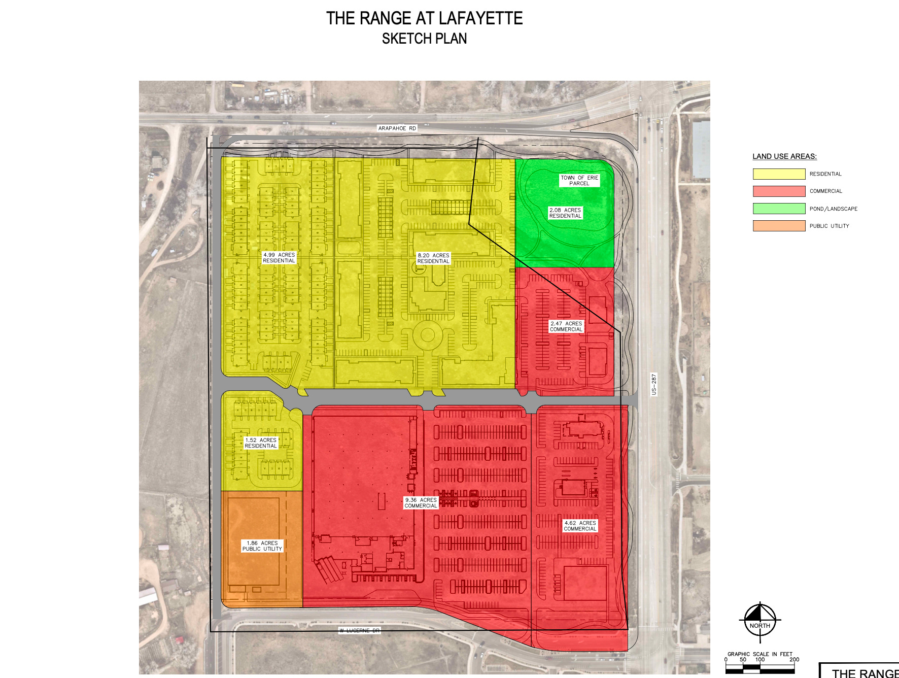
Currently located in unincorporated Boulder County, the 38.6-acre project - comprised of the 35.10-acre Tebo Parcel, and the 3.5-acre Erie Parcel - is in the process of being annexed into The City of Lafayette. Pursuant to the Lafayette Municipal Code, the sketch plan submitted herein will be followed by a Preliminary PUD application, a Final PUD application, and a Zoning application before final annexation, zoning, and PUD approval.
This Sketch plan serves to demonstrate the project’s planning objectives, its alignment with The Legacy Lafayette Comprehensive Plan, and, at a high-level, the proposed layout. Our overall goal is to develop the southwest corner of Arapahoe Road and Highway 287 into a vibrant retail and mixed-used center, providing opportunities for people to establish their home in Lafayette while also welcoming the public, neighbors and residents into The City of Lafayette.
Plan Evolution and Background
This Sketch PUD Plan aligns with the goals and urban design principles of The Legacy Lafayette Comprehensive Plan, but has been revised, where feasible, to address comments received from previous illustrative plan submission, previous sketch plan submissions and multiple neighborhood meetings and community feedback opportunities.
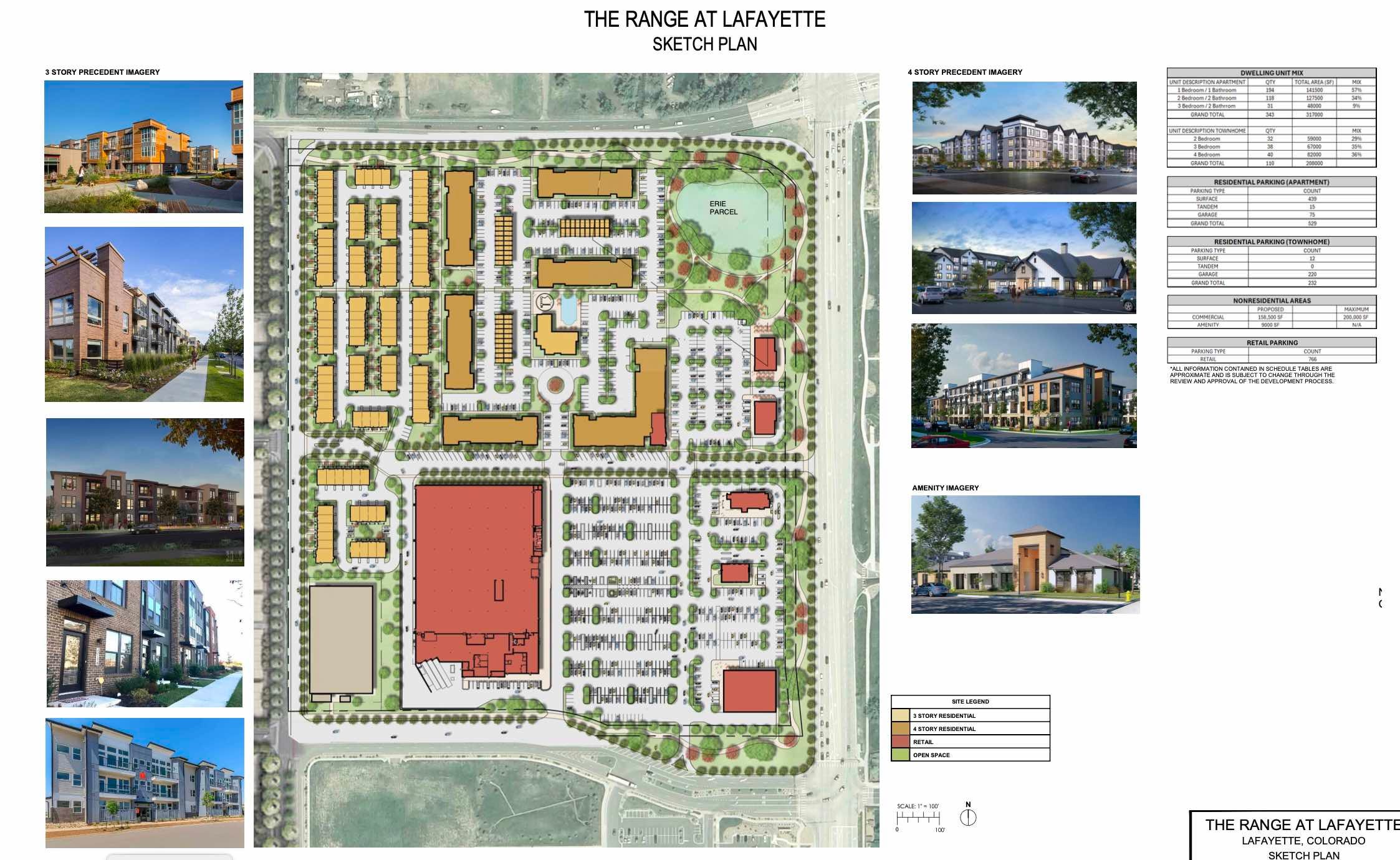
Feedback regarding building height, overall density of the project, and product type has led to increased unit diversity, reduced density and decreased building height where possible while maintaining overall project feasibility. Notably, while these changes have been incorporated the overall building footprint square footage has increased. The larger building footprints, combined with parking requirements, have constrained the ability to provide other minimum requirements, such as Public Land Dedication areas.
The original illustrative plan proposed approximately 650 rental apartment units housed in three- to fire- story buildings, along with roughly 150,000 SF of commercial square footage. The current Sketch Plan submission has reduced the number of units to 453, comprised of 343 proposed apartment units and 110 proposed for-sale townhomes. The townhome units will be limited to three stories in height, while the apartments will be limited to four stories. The proposed commercial square footage is approximately 158,500 square feet with the addition of integrated retail on the first floor of one of the apartment buildings. The configuration of the buildings has been updated to enhance pedestrian connectivity and ensure a smooth transition between neighboring properties to the south and the west.
Planning Objectives Achieved by the PUD
In alignment with the Adaptable Commercial Urban Design category, The Range at Lafayette creates a high-quality public realm, with sufficiently wide sidewalks to encourage outdoor dining and shopping, and the installation of public art, lighting, landscaping, and other features to enhance the experience for people walking and biking. The layout and combination of building types achieve a more sustainable initial mixed-use design, while allowing for potential transformations over time.
The Sketch Plan seeks to achieve these outcomes through a variety of specific urban design features that include:
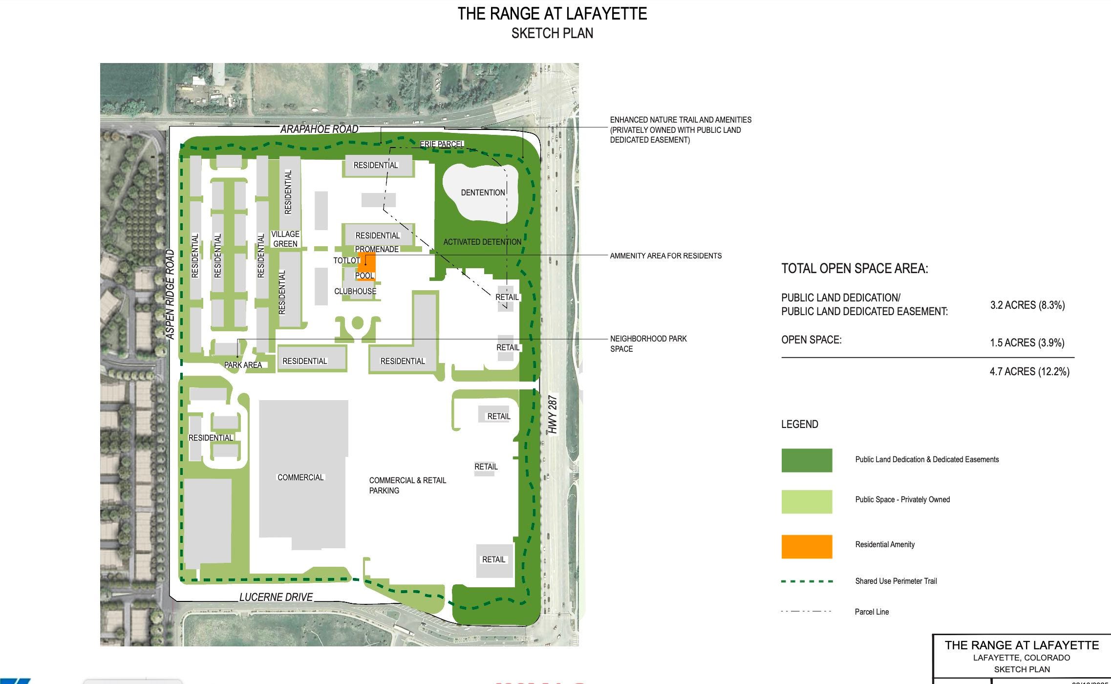
A mixed-use neighborhood with the right mix of residential to support a strong retail presence including a proposed general merchandise anchor and proposed specialty grocery along with multiple additional smaller retail opportunities that transition to surrounding existing retail neighborhoods. This includes a boutique retail opportunity on the first floor of an apartment building adjacent to the major transportation central corridor. A large common area open space in the northeast corner of the development will serve as an amenity to both the residents on-site and the surrounding neighborhoods.
A trail along the perimeter of the site will extend pedestrian walking and trail connections to residents and neighbors. In addition, there are ample pedestrian walkways throughout the interior of the site to allow for easy pedestrian connectivity. Attractive streetscapes, landscaping, and seating will activate the public realm.
The adaptive commercial topology anticipates three- to four-story residential buildings activating streets and taking advantage of mountain views in most areas. The primarily residential area complies with The Legacy Lafayette Comprehensive Plan, by providing three-story townhomes along the western edge of the site, blending into the scale of the planned adjacent project, Silo. The larger four-story buildings will be located in the central areas of the site and along Arapahoe Road. The strategic use of increased height will allow for the proposed first floor retail opportunity and an increased likelihood of affordable housing.
A grid of streets provides slower-moving residential streets to the north and west and more branded commercial streets to the south and east.
A BRT superstation is anticipated at the side of the development along Highway 287 to encourage multi- modal access to the site and its services.
Legacy Lafayette Comprehensive Plan Relationship
The existing Legacy Lafayette Comprehensive Plan, adopted in 2021, designates the site for adaptable commercial use. We have made a significant effort to accommodate public and city comments, urban design principles, and code requirements while maintaining a feasible project and attracting advantageous retail users like the general merchandise anchor and proposed specialty grocery. The plan provides for a thoughtful integration of the commercial and retail space and will encourage walkability from residents and the neighboring community to the planned retail. The plan also addresses the following:
Growth Management
The site is located within the city’s urban growth boundary. Additionally, following the intentions of the adaptable commercial guidelines, the site layout is organized in a grid of streets, where the southeastern quadrant of the site is surface parking and out lots. By focusing the density on the north and western quadrants of the site, we leave flexibility for future expansion along Highway 287 when market forces allow infill development.
Housing Diversity and Affordability
The plan has expanded upon its housing types by assuming a mix of four-story apartment buildings in the center of the site with three-story townhomes strategically located along the western third of the site, which decreases the scale as a transition to the adjacent project. These planned apartments and townhomes will help provide additional housing options and diversity to the residents of Lafayette.
Housing Locations
The entire site is very walkable and connected through a grid of small blocks around the perimeter and throughout the interior of the site. Residents are encouraged to walk on generous sidewalks and trail networks that connect common area open spaces, retail services, and transit.
Public Art and Gateway
There will be opportunities for public art displays within the common area open space or park space, along with the walkways to the commercial space. The plan assumes that Kensington will take ownership of the Erie parcel at the northeast corner of the development or have an easement to make improvements to this area. This area can remain a naturalized space but be enhanced to include walking paths, landscape improvements, and signage to create a larger gateway identity from this corner.
Public Realm
Development has been oriented to shape public realm spaces that encourage social interaction and human comfort in all seasons. The common area open space can be programmed as a neighborhood family amenity as well as a flexible space for events and gatherings. In addition, the walkable pedestrian connectivity and trails throughout the development plan allow the public to use all the programmed common area open space.
Neighborhood Destinations
With transit to the east and a walkable development with generous sidewalks and connections to the retail spaces, The Range at Lafayette will encourage compact development with greater intensity where feasible. The plan also provides walkable connectivity around the entirety of the site, allowing pedestrians to move from the commercial areas to the residential areas and parks/common area open space with ease and without the need for vehicular transportation.
Complete Neighborhoods
Carefully planned residential design and a mixture of commercial uses will provide the residents of the development and surrounding neighborhoods with many retail shopping choices right at their doorstep. Recreation trails connect common area open space destinations both along the perimeter and along internal streets to the residential and commercial portions of the site, providing a fully connected and complete neighborhood.
Additionally, the proposed The Range at Lafayette plan specifically addresses the following policies from the applicable elements of the Legacy Lafayette Comprehensive Plan.
Neighborhood and Local Design
2.1 The city will leverage regulatory standards to enhance streetscapes and provide for an enhanced public realm that is functional for all users and reflects the community’s aesthetic values.
2.2 The city will encourage the completion of connections from local neighborhoods to parks, common area open space areas, and other community destinations.
2.3 The city will encourage connections and neighborhood design that provides for walkability to neighborhood services.
2.5 The city will encourage transit-supportive development of sufficient density near transit corridors and in proximity to transit stops.
2.7 The city will encourage the development of neighborhoods that offer a full complement of amenities and features to serve people as they live, work, and play.
The site design will feature high-quality streetscape and public realm. Site circulation will connect to the Silo development, linking neighbors to the commercial and recreational amenities, services, and retail space to be developed. The proposed density of residential and commercial uses will support the existing and proposed transit along Highway 287 by providing a source of riders and destinations. The Range at Lafayette will provide the full complement of amenities and features for its residents and visitors: dwelling, shopping, recreation, and gathering.
Parks, Recreation, Open Space, and Wildlife Habitat
4.3 The city will strive to provide parks or open spaces within a 10-minute walk of every resident in Lafayette. The site will incorporate open space, park space, or land for other recreational purposes in an amount equal to or greater than 15% for residential or 12% for commercial of the gross land area. This may include a centrally located park and open spaces, which will be a public amenity. These spaces will further the goal of having parks and open space amenities within a 10-minute walk of every resident.
Public Land Dedication (PLD) and common area open space are priorities, and the current Sketch Plan indicates 4.7 Acres (12.2%) of PLD and common area open space. In response to feedback, the buildings have been reduced in height and the diversity of unit types has been increased. However, these changes have resulted in a larger building footprint. The larger footprints, combined with parking requirements for the residential occupants, the general merchandise anchor, and the proposed specialty grocery, have constrained the amount of space dedicated to open space, park space, or land for other recreational purposes.
Health and Wellness
5.8 The city will promote a wide range of food retail types interspersed across the community to limit gaps in access to healthy food.
A goal of the proposed development is to attract a variety of retail uses, including food retail types that will increase access to healthy food options.
Sustainable Infrastructure
7.5 The city will not annex new land into the city’s boundaries unless the land in question is included within the city’s urban growth boundary and the annexation occurs in a manner that provides an overall benefit to the community and conforms with The Legacy Lafayette Comprehensive Plan’s goals and policies.
The development site is located within Lafayette’s urban growth boundary.
Multi-Modal Mobility
8.1 The city will pursue opportunities to enhance local and regional connectivity, including regional trails and transit connections.
The proposed development will contain a connection to the existing and proposed transit along the Highway 287 corridor. The site design includes a walkable layout and ample open space, with a focus on a high-quality streetscape and public realm. Site circulation will connect to the Silo development, linking neighbors to commercial and recreational amenities and services, and the retail and commercial space to be developed. Additionally, recreational trails will connect common area open space destinations throughout the site.
Housing
12.2 The city will encourage residential development that supports the needs of a full spectrum of users, including but not limited to older adults, individuals of all abilities and backgrounds, first-time homebuyers, entry-to mid-level employees, move-up buyers, and cultural creatives through the provision of a variety of housing types, prices, styles, and sizes.
12.3 The city will support new affordable housing development that will be healthy and safe for the long term and located near childcare, transit, health services, and grocery stores.
12.4 The city will support housing diversity in terms of unit mix, size, bedroom configurations, and overall density in appropriate areas.
The development proposes approximately 343 rental apartments and 110 for-sale townhomes, adding to the supply and diversity of housing types within The City of Lafayette. This will offer more residential choices for city
residents and help meet the needs of a broad range of users. The proposed residential development will be situated near the existing and proposed transit along the Highway 287 corridor, and the proposed on-site retail.
Regional Cooperation
14.2 The city will work with regional and local service providers to ensure that future service extensions and improvements will be consistent with The Legacy Lafayette Comprehensive Plan.
The proposed uses, along with the associated infrastructure and services, are consistent with The Legacy Lafayette Comprehensive Plan.
Public Land Dedication
It is intended that the open areas depicted on the Public/Green Space Plan sheet, labeled as "Public Space – Privately Owned," will be accessible to the public but remain in private ownership. Spaces within and adjacent to the residential amenity area (labeled "Private Amenity") are intended for the exclusive use of the residents of the apartment community. Access and internal roads will remain in private ownership, with required access easements granted as necessary. The owners and tenants will contribute to a fund used to maintain the open areas, private access roads, and circulation.
Erie Parcel
The northeastern corner of the overall project contains a 3.5-acre parcel currently owned by the Town of Erie. Kensington intends to become the owner of the parcel and incorporate it into the project, as shown in the sketch plan. The property will accommodate a water tank for The Town of Erie located on the southwestern portion of the project site. We recognize the value of this area to the community and are working on ways to create a stormwater detention area that both preserves and enhances the natural landscape, transforming it into an attractive amenity. Additionally, it is important to note The Town of Erie has received a determination from the Army Corps of Engineers that this land area is not classified as wetlands.
The process for Erie parcel includes de-annexing the property from The Town of Erie, annexing the property into The City of Lafayette, and appropriately incorporating it into the PLAT/PUD/Zoning process for the project. The terms and schedule of the de-annexation from Erie and annexation into Lafayette are currently under negotiation
Affordable Housing
Kensington is in active discussion with the city regarding the affordable housing requirement. Our intent is to accommodate 12% of the apartment units as affordable housing at an AMI to be determined through the final agreement with the city. Once finalized the agreed-upon AMI will be shown on future PUD/PLAT submittals. The target AMI level for the for-rent apartment units is no less than 80% AMI on 12% of the for-rent apartment units, which, as stated, is subject to the final agreement with the city. To align with the priorities of The Legacy Lafayette Comprehensive Plan, the strategic use of increased building height, up to four-stories, will enable a total apartment count that supports project feasibility while accommodating the required affordable housing apartment units.
Sincerely,
Kensington Development Partners
Edgar Crockett
Development Services Project Manager
Want to offer more support? Awesome!
We don't need more parking lots, fast food chains, or big-box stores. Instead, let's create vibrant, walkable spaces that bring people together! Stanley Marketplace in Denver is a great example of what's possible when we prioritize community-driven design.
📍Small squares lined with unique shops, cafes, and restaurants
👥 Places where friends and family can gather, socialize, and enjoy each other's company
🍺 Local bars and restaurants that showcase our community's personality
🌿 Green spaces that inspire connection, add a bocce ball court, or corn hole, etc.
🌉 While we are at it, let's build a cycling/walking tunnel or bridge under/over 287 to connect the North West and North East side of Lafayette.
Let's prioritize people over parking lots! Let's build a neighborhood that's designed for humans, not just cars.
Is the March meeting in addition to the February 27th meeting.