

Questions about HB 24-1313? No wonder.
Here's some more information


Hopefully, you’re over the shock of reading my report on House Bill 24-1313 and its impact on Lafayette. You might have a few questions. Let’s jump right into some more background. I will once again utilize some slides from our planning staff’s presentation to the city council.
Want to really dive in and watch the staff presentations to the city council?
On March 5
On March 19
WHAT IS A TRANSIT ORIENTED COMMUNITY AND WHY ARE WE ONE?
Here’s the definition.

Lafayette is a member of the Denver Regional Council of Governments (DRCOG) which is a Metropolitan Planning Organization (MPO).
Our population is 30,670.
Transit areas are defined as being 1/4 mile from transit stations and transit corridors.

The 15-minute frequency for a bus route doesn’t mean all day. There could be a route with a bus every two hours except during rush hour when there are two buses that are 15 minutes apart. At its highest frequency, the JUMP route qualifies.
Also bus routes change, not only in the route itself but in frequency. This means planning around a possible moving target.
The Colorado Department of Transportation tells us that “Bus Rapid Transit (BRT) is a high quality, bus-based transit system designed to be more reliable, convenient, and faster than traditional bus service.”
STAFF ANALYSIS OF BUS RAPID TRANSIT (BRT)
“DRCOG Metro Vision 2050 lists both Hwy 287 and SH 7 BRT projects as planning corridors with Hwy 287 planned for implementation in the 2030-2040 timeframe and SH 7 in the 2040-2050 timeframe.
SH 7 has a commuter starter service coming in 2026 that is planned to be upgraded to BRT when the infrastructure is in place to support this. This may mean that SH 7 BRT arrives prior to Hwy 287. The starter service only has 30 minute service planned.
An example of Commuter BRT is the Flatiron Flyer that Runs between Denver Union Station and Boulder. Hwy 287 BRT could be classified as this type of service.”
ZONING CHANGES CAUSED BY A HOG
The bill requires the establishment of a Housing Opportunity Goal (HOG).
Taking the defined transit area and subtracting any exempt parcels, what remains must be zoned to allow for at least 40 dwelling units per acre, that’s the HOG. This includes already developed land, not just undeveloped.
In an analysis document, city staff states “this overall density calculation is magnitudes higher than current densities in the city. Newer neighborhoods, like Silo and 40 North are averaging around 10 DU/Acre.”

THE TRANSIT AREAS
City staff created this map of Lafayette’s transit areas.
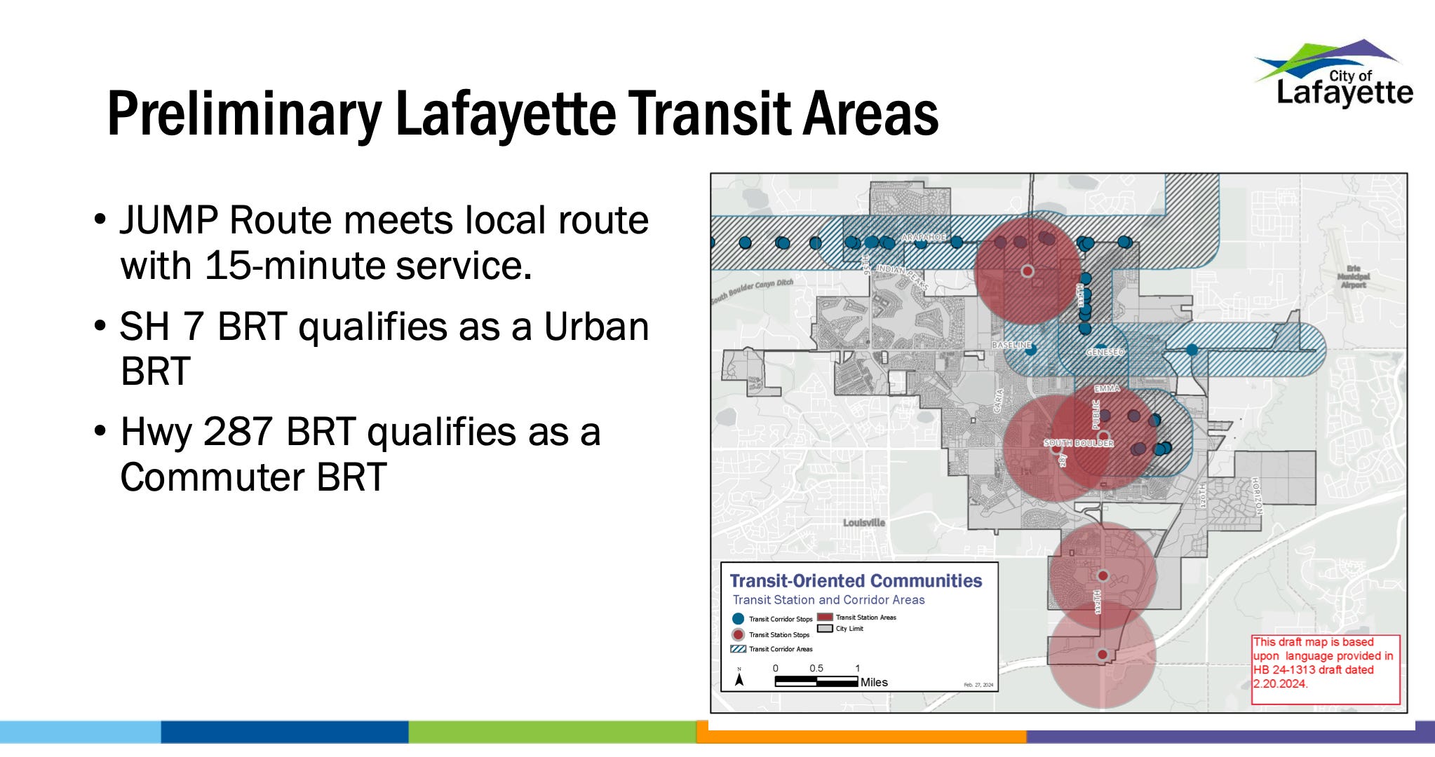
Here’s a larger version

OTHER REQUIREMENTS
The city must create strategies to address affordability and issues related to displacement of residents.
Detailed and time consuming reports must be filed with the state every three years in perpetuity.
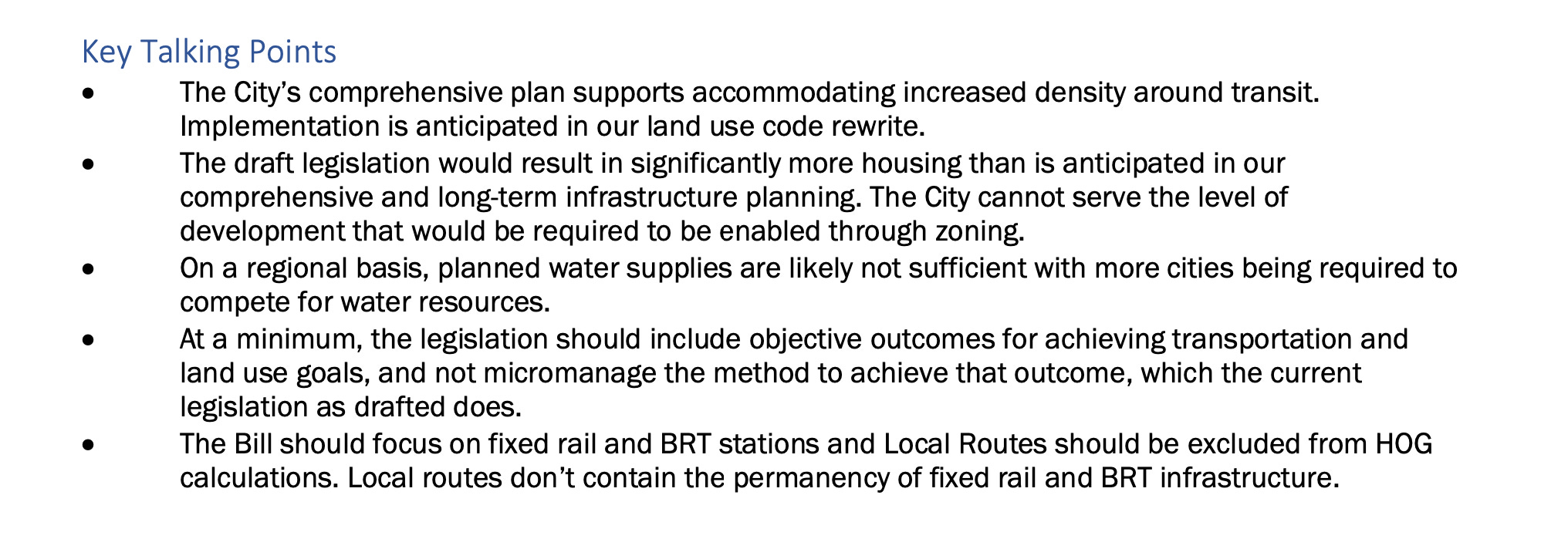
THE CITY’S POINTS
SOME DENSITY EXAMPLES
I’ve been reporting on Willoughby Corner, the Boulder County Housing Authority affordable housing project currently being constructed at Emma and 120th. As a member of the East Lafayette Advisory Committee (ELAC) for that project I reached out to our planning manager in 2019 to ask about the density of some areas in the community.
Here’s what I was told at that time:
Willoughby Corner was planned at 401 units (It’s 400 now). The site is 24.10 acres 401/24.10 = 16.64 dwelling units per acre (du/ac).
Coal Creek Village is 6.1 du/ac
South Pointe multi-family is 14.5 du/ac, single family is 2.7 du/ac
The Copperstone apartments near Exempla are 16 du/ac
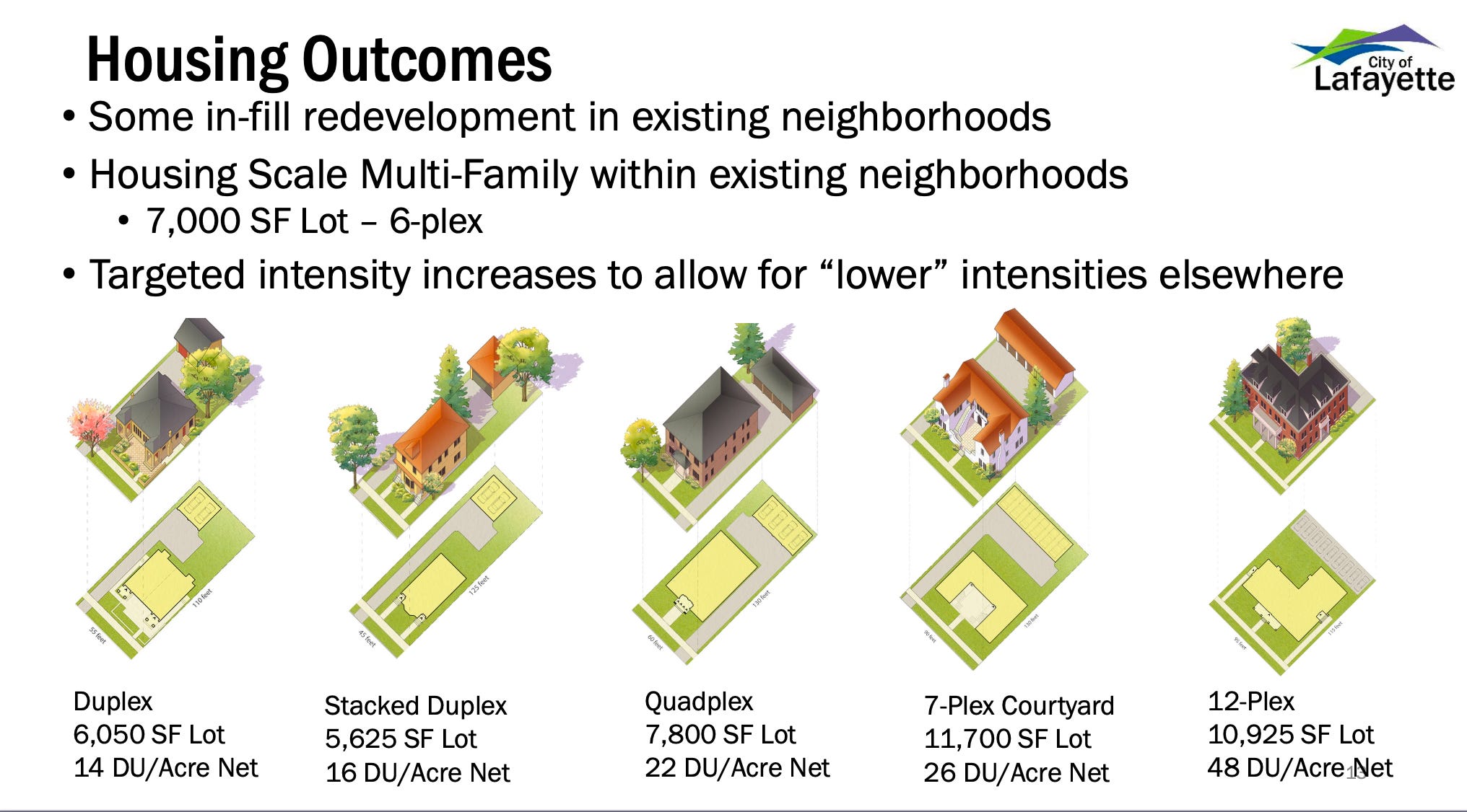
STAFF’S EXAMPLES TO INCREASE DENSITY IN EXISTING NEIGHBORHOODS
If we don’t have enough water now, how do we agree to adding more residences.
Who committed Lafayette to the addition of more population?